 |
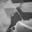
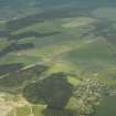
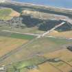
On-line Digital Images |
SC 1010430 |
Records of Aberdeen Aerial Surveys, Aberdeen, Scotland |
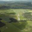
Oblique aerial view centred on the cropmarks of the unenclosed settlement, ring ditches and enclosures at Lower Auchenreath with Dallachy airfield adjacent, looking to the SE. |
3/8/1985 |
Item Level |
|
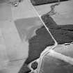 |
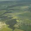
On-line Digital Images |
SC 1010436 |
Records of Aberdeen Aerial Surveys, Aberdeen, Scotland |
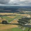
Oblique aerial view centred on the cropmarks of the unenclosed settlement, ring ditches and enclosures at Lower Auchenreath with Dallachy airfield adjacent, looking to the SE. |
3/8/1985 |
Item Level |
|
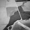 |
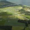
On-line Digital Images |
SC 1010437 |
Records of Aberdeen Aerial Surveys, Aberdeen, Scotland |
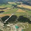
Oblique aerial view centred on the cropmarks of the unenclosed settlement, ring ditches and enclosures at Lower Auchenreath with Dallachy airfield adjacent, looking to the SE. |
3/8/1985 |
Item Level |
|
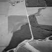 |
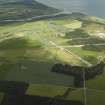
On-line Digital Images |
SC 1010438 |
Records of Aberdeen Aerial Surveys, Aberdeen, Scotland |
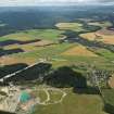
Oblique aerial view centred on the cropmarks of the unenclosed settlement, ring ditches and enclosures at Lower Auchenreath with Dallachy airfield adjacent, looking to the SE. |
3/8/1985 |
Item Level |
|
 |
On-line Digital Images |
DP 018465 |
RCAHMS Aerial Photography Digital |
General oblique aerial view centred on the remains of the airfield with the village adjacent, taken from the NNW. |
6/7/2006 |
Item Level |
|
 |
On-line Digital Images |
DP 018466 |
RCAHMS Aerial Photography Digital |
General oblique aerial view centred on the remains of the airfield with the village adjacent, taken from the NNW. |
6/7/2006 |
Item Level |
|
 |
On-line Digital Images |
DP 019300 |
RCAHMS Aerial Photography Digital |
General oblique aerial view centred on the airfield with the villages in the distance, taken from the SE. |
7/7/2006 |
Item Level |
|
 |
On-line Digital Images |
DP 019301 |
RCAHMS Aerial Photography Digital |
General oblique aerial view centred on the airfield with the villages in the distance, taken from the ESE. |
7/7/2006 |
Item Level |
|
 |
On-line Digital Images |
DP 019302 |
RCAHMS Aerial Photography Digital |
General oblique aerial view centred on the airfield with the villages in the distance, taken from the E. |
7/7/2006 |
Item Level |
|
 |
On-line Digital Images |
DP 065340 |
RCAHMS Aerial Photography Digital |
General oblique aerial view centred on the remains of the airfield, taken from the E. |
25/7/2009 |
Item Level |
|
 |
On-line Digital Images |
DP 065341 |
RCAHMS Aerial Photography Digital |
General oblique aerial view centred on the remains of the airfield, taken from the N. |
25/7/2009 |
Item Level |
|
 |
On-line Digital Images |
DP 065342 |
RCAHMS Aerial Photography Digital |
General oblique aerial view centred on the remains of the airfield, taken from the NNW. |
25/7/2009 |
Item Level |
|
 |
On-line Digital Images |
DP 163293 |
RCAHMS Aerial Photography Digital |
General oblique aerial view centred on Dallachy Airfield, looking NNW. |
31/7/2013 |
Item Level |
|
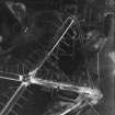 |
On-line Digital Images |
SC 2552569 |
RAF Second World War Aerial Photography of Scotland |
RAF WWII vertical aerial photograph showing the runways during the construction phase.Also visible are areas of anti-landing ditches on the limits of Spey Bay. |
21/2/1943 |
Item Level |
|
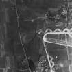 |
On-line Digital Images |
SC 2552570 |
RAF Second World War Aerial Photography of Scotland |
RAF WWII vertical aerial photograph of W part of airfield during the construction phase.Visible are taxiways and part of E-W runway. Also seen on the image is the small village of Nether Dallachy. |
21/2/1943 |
Item Level |
|
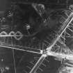 |
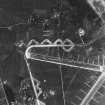
On-line Digital Images |
SC 2552571 |
RAF Second World War Aerial Photography of Scotland |
RAF WWII vertical aerial photograph of the main runway crossing point of Dallachy Airfield during the construction phase. Visible are several anti-landing ditches. |
21/2/1943 |
Item Level |
|
 |
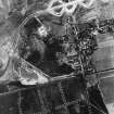
On-line Digital Images |
SC 2552572 |
RAF Second World War Aerial Photography of Scotland |
RAF WWII vertical aerial photograph of the NW part of Dallachy Airfield during the construction phase. Visible are part of the main runways, the perimeter track and technical area. Also visible is the small village of Nether Dallachy |
21/2/1943 |
Item Level |
|
 |
On-line Digital Images |
SC 2552573 |
RAF Second World War Aerial Photography of Scotland |
RAF WWII vertical aerial photograph of the NE part of Dallachy Airfield during the construction phase. Visible is part of the perimeter track and taxiways. Also visible is the small village of Nether Dallachy and an area of freshly dug anti-landing ditches to the NE of the village. |
21/2/1943 |
Item Level |
|


