 |
On-line Digital Images |
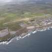
DP 139220 |
RCAHMS Aerial Photography Digital |
General oblique view of Dounreay Nuclear Power Development Establishment, and the disused airfield, looking to the SE. |
19/7/2012 |
Item Level |
|
 |
On-line Digital Images |
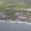
DP 139300 |
RCAHMS Aerial Photography Digital |
Oblique aerial view of Dounreay Nuclear Development Establishment, centred on the site of the storehouses, looking SE. |
19/7/2012 |
Item Level |
|
 |
On-line Digital Images |
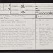
SC 2350963 |
Records of the Ordnance Survey, Southampton, Hampshire, England |
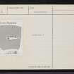
'Cnoc Na H-Uiseig', Lower Dounreay, NC96NE 6, Ordnance Survey index card, page number 1, Recto |
1958 |
Item Level |
|
 |
On-line Digital Images |
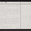
SC 2350964 |
Records of the Ordnance Survey, Southampton, Hampshire, England |
'Cnoc Na H-Uiseig', Lower Dounreay, NC96NE 6, Ordnance Survey index card, page number 2, Verso |
1958 |
Item Level |
|
 |
On-line Digital Images |
SC 2350965 |
Records of the Ordnance Survey, Southampton, Hampshire, England |
'Cnoc Na H-Uiseig', Lower Dounreay, NC96NE 6, Ordnance Survey index card, Recto |
1958 |
Item Level |
|
 |
On-line Digital Images |
SC 2350966 |
Records of the Ordnance Survey, Southampton, Hampshire, England |
'Cnoc Na H-Uiseig', Lower Dounreay, NC96NE 6, Ordnance Survey index card, Recto |
1958 |
Item Level |
|


