 |
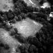
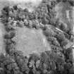
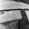
On-line Digital Images |
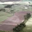
SC 349331 |
|
Tocherknowe, oblique aerial view, centred on the cropmarks of a Roman fortlet. |
|
Item Level |
|
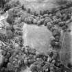 |
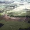
On-line Digital Images |
SC 1732795 |
RCAHMS Aerial Photography |
Tocherknowe, oblique aerial view, centred on the cropmarks of a Roman fortlet. |
1989 |
Item Level |
|
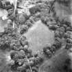 |
On-line Digital Images |
SC 1732796 |
RCAHMS Aerial Photography |
Tocherknowe, oblique aerial view, centred on the cropmarks of a Roman fortlet. |
1989 |
Item Level |
|
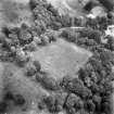 |
On-line Digital Images |
SC 1732797 |
RCAHMS Aerial Photography |
Tocherknowe, oblique aerial view, centred on the cropmarks of a Roman fortlet. |
1989 |
Item Level |
|
 |
On-line Digital Images |
SC 1732798 |
RCAHMS Aerial Photography |
Tocherknowe, oblique aerial view, centred on the cropmarks of a Roman fortlet. |
1989 |
Item Level |
|
 |
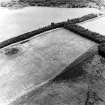
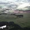
On-line Digital Images |
SC 1732830 |
RCAHMS Aerial Photography |
Cock Rig, oblique aerial view, taken from the SSW, centred on the Border-Crawford-Inveresk Roman Road and quarry pits. |
21/8/1995 |
Item Level |
|
 |
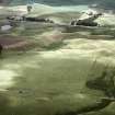
On-line Digital Images |
SC 1732831 |
RCAHMS Aerial Photography |
Cock Rig, oblique aerial view, taken from the SSE, centred on the Border-Crawford-Inveresk Roman Road and quarry pits. |
21/8/1995 |
Item Level |
|
 |
On-line Digital Images |
SC 1732832 |
RCAHMS Aerial Photography |
Cock Rig, oblique aerial view, taken from the NNW, centred on the Border-Crawford-Inveresk Roman Road and quarry pits. |
21/8/1995 |
Item Level |
|
 |
On-line Digital Images |
SC 1732833 |
RCAHMS Aerial Photography |
Cock Rig, oblique aerial view, taken from the NW, centred on the Border-Crawford-Inveresk Roman Road and quarry pits. |
21/8/1995 |
Item Level |
|
 |
On-line Digital Images |
SC 1939358 |
John Dent |
NT 12 50. |
1992 |
Item Level |
|
 |
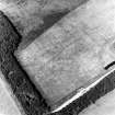
On-line Digital Images |
SC 1939359 |
John Dent |
NT 12 50. |
1992 |
Item Level |
|
 |
On-line Digital Images |
SC 1939360 |
John Dent |
NT 12 50. |
1992 |
Item Level |
|
 |
On-line Digital Images |
SC 1939361 |
John Dent |
NT 12 50. |
1992 |
Item Level |
|


