 |
On-line Digital Images |
SC 1710319 |
RCAHMS Aerial Photography |
Oblique aerial view. |
1992 |
Item Level |
|
 |
On-line Digital Images |
SC 1710377 |
RCAHMS Aerial Photography |
Oblique aerial view. |
1988 |
Item Level |
|
 |
On-line Digital Images |
SC 1710378 |
RCAHMS Aerial Photography |
Oblique aerial view. |
1988 |
Item Level |
|
 |
On-line Digital Images |
SC 1710379 |
RCAHMS Aerial Photography |
Oblique aerial view. |
1988 |
Item Level |
|
 |
On-line Digital Images |
SC 1710439 |
RCAHMS Aerial Photography |
Oblique aerial view. |
1992 |
Item Level |
|
 |
On-line Digital Images |
SC 1710440 |
RCAHMS Aerial Photography |
Oblique aerial view. |
1992 |
Item Level |
|
 |
On-line Digital Images |
SC 1710441 |
RCAHMS Aerial Photography |
Oblique aerial view. |
1992 |
Item Level |
|
 |
On-line Digital Images |
SC 1710442 |
RCAHMS Aerial Photography |
Oblique aerial view. |
1992 |
Item Level |
|
 |
On-line Digital Images |
SC 1710443 |
RCAHMS Aerial Photography |
Oblique aerial view. |
1992 |
Item Level |
|
 |
On-line Digital Images |
SC 1710444 |
RCAHMS Aerial Photography |
Oblique aerial view. |
1992 |
Item Level |
|
 |
On-line Digital Images |
SC 1710454 |
RCAHMS Aerial Photography |
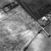
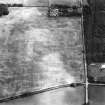
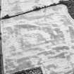
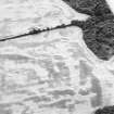
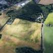
Myreside, oblique aerial view, taken from the ENE, showing cropmarks, including those of a ring ditch and a possible pit-defined enclosure, in the centre. A linear cropmark runs from the centre to the bottom edge of the photograph. |
28/7/1994 |
Item Level |
|
 |
On-line Digital Images |
SC 1710455 |
RCAHMS Aerial Photography |
Myreside, oblique aerial view, taken from the NNW, showing cropmarks, including those of a ring ditch and a possible pit-defined enclosure, in the centre. A linear cropmark runs across the centre of the photograph. |
28/7/1994 |
Item Level |
|
 |
On-line Digital Images |
SC 1710456 |
RCAHMS Aerial Photography |
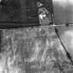
Myreside, oblique aerial view, taken from the NW, showing cropmarks, including those of a ring ditch and a possible pit-defined enclosure, in the centre. A linear cropmark runs from the top left-hand corner towards the centre of the photograph. |
28/7/1994 |
Item Level |
|
 |
On-line Digital Images |
SC 1710457 |
RCAHMS Aerial Photography |
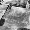
Myreside, oblique aerial view, taken from the W, showing cropmarks, including those of a ring ditch and a possible pit-defined enclosure, in the centre. A linear cropmark runs up the centre of the photograph. Further cropmarks, of a pit alignment and a possible enclosure, are visible in the top left-hand corner. |
28/7/1994 |
Item Level |
|
 |
On-line Digital Images |
SC 1710497 |
RCAHMS Aerial Photography |
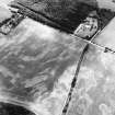
Oblique aerial view centred on the cropmarks of the ring-ditch, field boundary, possible pit-defined enclosure, pit-alignment, pits and frost wedges, taken from the E. |
31/7/2001 |
Item Level |
|
 |
On-line Digital Images |
SC 1710498 |
RCAHMS Aerial Photography |
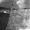
Oblique aerial view centred on the cropmarks of the ring-ditch, field boundary, possible pit-defined enclosure, pit-alignment, pits and frost wesges, taken from the ENE. |
31/7/2001 |
Item Level |
|
 |
On-line Digital Images |
SC 1710499 |
RCAHMS Aerial Photography |
Oblique aerial view centred on the cropmarks of the ring-ditch, field boundary, possible pit-defined enclosure, pit-alignment, pits and frost wedges, taken from the NNW. |
31/7/2001 |
Item Level |
|
 |
On-line Digital Images |
SC 1783606 |
RCAHMS Aerial Photography |
Print generated from slide |
1992 |
Item Level |
|
 |
On-line Digital Images |
SC 1860632 |
RCAHMS Aerial Photography |
Oblique aerial view. |
1988 |
Item Level |
|
 |
On-line Digital Images |
SC 2011235 |
RCAHMS Aerial Photography |
Oblique aerial view. |
1992 |
Item Level |
|
 |
On-line Digital Images |
DP 392761 |
Historic Environment Scotland |
Oblique aerial view |
4/8/2022 |
Item Level |
|


