 |
On-line Digital Images |
SC 1761417 |
RCAHMS Aerial Photography |
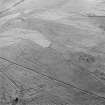
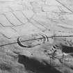
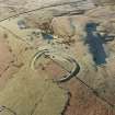
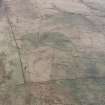
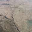
Oblique aerial view of Side centred on the remains of boundary ditches, farmstead, sheep stell, field-system, rig and lazy beds with a farmstead, field-system, rig and boundary banks adjacent and a fort and palisaded enclosure in the background, taken from the S. |
1/12/1997 |
Item Level |
|
 |
On-line Digital Images |
SC 1761418 |
RCAHMS Aerial Photography |
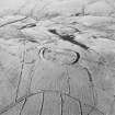
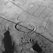
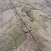
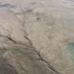
Oblique aerial view of Kirk Hill centred on the remains of a fort and palisaded enclosure with a farmstead, field-system, rig and boundary banks and buildings, enclosures, lazy-beds and quarries adjacent, taken from the E. |
1/12/1997 |
Item Level |
|
 |
On-line Digital Images |
SC 1761419 |
RCAHMS Aerial Photography |
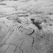
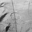
Oblique aerial view of Kirk Hill centred on the remains of a fort and palisaded enclosure with a farmstead, field-system, rig and boundary banks and buildings, enclosures, lazy-beds and quarries adjacent, taken from the E. |
1/12/1997 |
Item Level |
|
 |
On-line Digital Images |
SC 1761420 |
RCAHMS Aerial Photography |
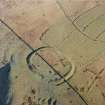
Oblique aerial view of Kirk Hill centred on the remains of a fort and palisaded enclosure with a farmstead, field-system, rig and boundary banks and buildings, enclosures, lazy-beds and quarries adjacent, taken from the N. |
1/12/1997 |
Item Level |
|
 |
On-line Digital Images |
SC 1761421 |
RCAHMS Aerial Photography |
Oblique aerial view of Kirk Hill centred on the remains of a fort and palisaded enclosure with a farmstead, field-system, rig and boundary banks and buildings, enclosures, lazy-beds and quarries adjacent, taken from the NW. |
1/12/1997 |
Item Level |
|
 |
On-line Digital Images |
SC 1761422 |
RCAHMS Aerial Photography |
Oblique aerial view of Kirk Hill centred on the remains of a fort and palisaded enclosure with a farmstead, field-system, rig and boundary banks and buildings, enclosures, lazy-beds and quarries adjacent, taken from the W. |
1/12/1997 |
Item Level |
|
 |
On-line Digital Images |
SC 1761423 |
RCAHMS Aerial Photography |
Oblique aerial view of Kirk Hill centred on the remains of a fort and palisaded enclosure with a farmstead, field-system, rig and boundary banks and buildings, enclosures, lazy-beds and quarries adjacent, taken from the SW. |
1/12/1997 |
Item Level |
|
 |
On-line Digital Images |
SC 1761462 |
RCAHMS Aerial Photography |
Oblique aerial view of Kirk Hill centred on the remains of a fort and palisaded enclosure with the remains of a farmstead, field-system, rig and boundary banks adjacent, taken from the W. |
1/12/1997 |
Item Level |
|
 |
On-line Digital Images |
SC 1761463 |
RCAHMS Aerial Photography |
Oblique aerial view of Kirk Hill centred on the remains of a fort and palisaded enclosure with the remains of buildings, enclosures, lazy-beds, quarries, a farmstead, field-system, rig and boundary banks adjacent, taken from the E. |
1/12/1997 |
Item Level |
|
 |
On-line Digital Images |
SC 1761472 |
RCAHMS Aerial Photography |
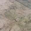
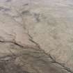
Oblique aerial view centred on the remains of the fort and palisaded enclosure with field-system, rig, boundary banks, enclosures and lazy beds adjacent, taken from the NE. |
27/3/2000 |
Item Level |
|
 |
On-line Digital Images |
SC 1761473 |
RCAHMS Aerial Photography |
Oblique aerial view centred on the remains of the fort and palisaded enclosure with field-system, rig, boundary banks, enclosures and lazy beds adjacent, taken from the NW. |
27/3/2000 |
Item Level |
|
 |
On-line Digital Images |
SC 1761474 |
RCAHMS Aerial Photography |
Oblique aerial view centred on the remains of the fort and palisaded enclosure, field-system, rig and boundary banks with enclosures, lazy beds, boundary ditches, field-system and rig adjacent, taken from the WNW. |
27/3/2000 |
Item Level |
|
 |
On-line Digital Images |
SC 1761475 |
RCAHMS Aerial Photography |
Oblique aerial view centred on the remains of the fort and palisaded enclosure, field-system, rig and boundary banks with enclosures, lazy beds, boundary ditches, field-system and rig adjacent, taken from the SW. |
27/3/2000 |
Item Level |
|
 |
On-line Digital Images |
SC 1761476 |
RCAHMS Aerial Photography |
Oblique aerial view centred on the remains of the fort and palisaded enclosure with field-system, rig, boundary banks, enclosures and lazy beds adjacent, taken from the SW. |
27/3/2000 |
Item Level |
|
 |
On-line Digital Images |
SC 1761477 |
RCAHMS Aerial Photography |
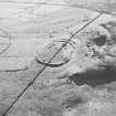
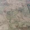
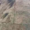
General oblique aerial view looking over the sheep stell towards the remains of the fort, palisaded enclosure, farmstead, cottage and sheepfold, taken from the WSW. |
27/3/2000 |
Item Level |
|
 |
On-line Digital Images |
SC 1761478 |
RCAHMS Aerial Photography |
General oblique aerial view looking over the sheep stell towards the remains of the fort, palisaded enclosure, farmstead, cottage and sheepfold, taken from the SW. |
27/3/2000 |
Item Level |
|
 |
On-line Digital Images |
SC 1761479 |
RCAHMS Aerial Photography |
General oblique aerial view looking over the sheep stell towards the remains of the fort, palisaded enclosure, farmstead, cottage and sheepfold, taken from the SW. |
27/3/2000 |
Item Level |
|
|
Photographs and Off-line Digital Images |
SC 1932802 |
Cambridge University Collection for Aerial Photography |
|
1979 |
Item Level |
|
|
Digital Files (Non-image) |
DX 001442 |
Records of the Royal Commission on the Ancient and Historical Monuments of Scotland (RCAHMS), Edinbu |
RCAHMS Structures Database - Liddesdale survey |
1996 |
Item Level |
|
 |
On-line Digital Images |
SC 2086547 |
Records of the Royal Commission on the Ancient and Historical Monuments of Scotland (RCAHMS), Edinbu |
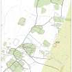
Map showing the archaeological landscape around Kirkhill, Liddesdale |
2001 |
Item Level |
|
 |
On-line Digital Images |
SC 2086555 |
Records of the Royal Commission on the Ancient and Historical Monuments of Scotland (RCAHMS), Edinbu |
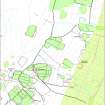
Map of archaeological landscape around Kirkhill, Liddesdale |
2001 |
Item Level |
|
|
Digital Files (Non-image) |
TM 000559 |
Records of the Royal Commission on the Ancient and Historical Monuments of Scotland (RCAHMS), Edinbu |
Zip file containing all the survey linework collected during the RCAHMS Afforestable Land Survey of Liddesdale |
1996 |
Item Level |
|
 |
On-line Digital Images |
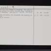
SC 2473018 |
Records of the Ordnance Survey, Southampton, Hampshire, England |
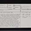
Kirk Hill, NY48NE 1, Ordnance Survey index card, page number 1, Recto |
1958 |
Item Level |
|
 |
On-line Digital Images |
SC 2473019 |
Records of the Ordnance Survey, Southampton, Hampshire, England |
Kirk Hill, NY48NE 1, Ordnance Survey index card, page number 2, Verso |
1958 |
Item Level |
|


