|
Photographs and Off-line Digital Images |
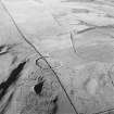
D 46391 CN |
RCAHMS Aerial Photography |
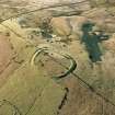
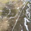
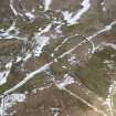
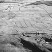
Oblique aerial view centred on the remains of the fort and palisaded enclosure with field-system, rig, boundary banks, enclosures and lazy beds adjacent, taken from the NW. |
27/3/2000 |
Item Level |
|
|
Photographs and Off-line Digital Images |
D 46392 CN |
RCAHMS Aerial Photography |
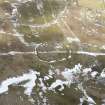
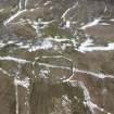
Oblique aerial view centred on the remains of the fort and palisaded enclosure, field-system, rig and boundary banks with enclosures, lazy beds, boundary ditches, field-system and rig adjacent, taken from the WNW. |
27/3/2000 |
Item Level |
|
|
Photographs and Off-line Digital Images |
D 46393 CN |
RCAHMS Aerial Photography |
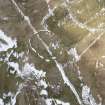
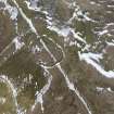
Oblique aerial view centred on the remains of the fort and palisaded enclosure, field-system, rig and boundary banks with enclosures, lazy beds, boundary ditches, field-system and rig adjacent, taken from the SW. |
27/3/2000 |
Item Level |
|
|
Photographs and Off-line Digital Images |
D 46395 CN |
RCAHMS Aerial Photography |
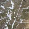
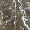
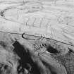
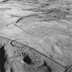
General oblique aerial view looking over the sheep stell towards the remains of the fort, palisaded enclosure, farmstead, cottage and sheepfold, taken from the WSW. |
27/3/2000 |
Item Level |
|
|
Photographs and Off-line Digital Images |
D 46396 CN |
RCAHMS Aerial Photography |
General oblique aerial view looking over the sheep stell towards the remains of the fort, palisaded enclosure, farmstead, cottage and sheepfold, taken from the SW. |
27/3/2000 |
Item Level |
|
|
Photographs and Off-line Digital Images |
D 46397 CN |
RCAHMS Aerial Photography |
General oblique aerial view looking over the sheep stell towards the remains of the fort, palisaded enclosure, farmstead, cottage and sheepfold, taken from the SW. |
27/3/2000 |
Item Level |
|
|
Digital Files (Non-image) |
GV 005084 |
Records of the Royal Commission on the Ancient and Historical Monuments of Scotland (RCAHMS), Edinbu |
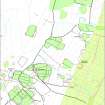
Digital map (colour) of archaeological landscape around Kirkhill, Liddesdale in Adobe Illustrator format |
2001 |
Item Level |
|
 |
On-line Digital Images |
DP 228303 |
Records of the Royal Commission on the Ancient and Historical Monuments of Scotland (RCAHMS), Edinbu |
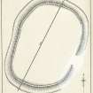
Publication drawing; Earthwork, Kirk Hill. |
c. 1933 |
Item Level |
|
 |
On-line Digital Images |
DP 228304 |
Records of the Royal Commission on the Ancient and Historical Monuments of Scotland (RCAHMS), Edinbu |
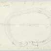
Plane-table survey; Earthwork, Kirk Hill. |
7/6/1933 |
Item Level |
|
 |
On-line Digital Images |
SC 423309 |
RCAHMS Aerial Photography |
General oblique aerial view of Ettleton Sike centred on the burial-ground, taken from the E. |
1/12/1997 |
Item Level |
|
 |
On-line Digital Images |
SC 759246 |
RCAHMS Aerial Photography |
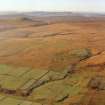
Oblique aerial view of Kirk Hill centred on the remains of a fort and palisaded enclosure with the remains of buildings, enclosures, lazy-beds, quarries, a farmstead, field-system, rig and boundary banks adjacent, taken from the E. Digital image of D/24598/CN. |
1/12/1997 |
Item Level |
|
 |
On-line Digital Images |
DP 274656 |
Historic Environment Scotland |
Oblique aerial view. |
9/3/2018 |
Item Level |
|
 |
On-line Digital Images |
DP 274657 |
Historic Environment Scotland |
Oblique aerial view. |
9/3/2018 |
Item Level |
|
 |
On-line Digital Images |
DP 274658 |
Historic Environment Scotland |
Oblique aerial view. |
9/3/2018 |
Item Level |
|
 |
On-line Digital Images |
DP 274659 |
Historic Environment Scotland |
Oblique aerial view. |
9/3/2018 |
Item Level |
|
 |
On-line Digital Images |
DP 274660 |
Historic Environment Scotland |
Oblique aerial view. |
9/3/2018 |
Item Level |
|
 |
On-line Digital Images |
DP 274661 |
Historic Environment Scotland |
Oblique aerial view. |
9/3/2018 |
Item Level |
|
 |
On-line Digital Images |
DP 274662 |
Historic Environment Scotland |
Oblique aerial view. |
9/3/2018 |
Item Level |
|
 |
On-line Digital Images |
DP 274663 |
Historic Environment Scotland |
Oblique aerial view. |
9/3/2018 |
Item Level |
|
 |
On-line Digital Images |
SC 1671555 |
Records of the Royal Commission on the Ancient and Historical Monuments of Scotland (RCAHMS), Edinbu |
Digital map (colour) of archaeological landscape around Kirkhill, Liddesdale |
|
Item Level |
|
 |
On-line Digital Images |
SC 1761412 |
RCAHMS Aerial Photography |
Oblique aerial view of Kirk Hill centred on the remains of a fort and palisaded enclosure with buildings, enclosures, lazy-beds, quarries and a farmstead, field-system, rig and boundary bank adjacent, taken from the NW. |
1/12/1997 |
Item Level |
|
 |
On-line Digital Images |
SC 1761413 |
RCAHMS Aerial Photography |
Oblique aerial view of Kirk Hill centred on the remains of a fort and palisaded enclosure with buildings, enclosures, lazy-beds, quarries and a farmstead, field-system, rig and boundary bank adjacent, taken from the WNW. |
1/12/1997 |
Item Level |
|
 |
On-line Digital Images |
SC 1761414 |
RCAHMS Aerial Photography |
Oblique aerial view of Kirk Hill centred on the remains of a fort and palisaded enclosure with buildings, enclosures, lazy-beds, quarries and a farmstead, field-system, rig and boundary banks adjacent, taken from the W. |
1/12/1997 |
Item Level |
|
 |
On-line Digital Images |
SC 1761415 |
RCAHMS Aerial Photography |
Oblique aerial view of Kirk Hill centred on the remains of a fort and palisaded enclosure with buildings, enclosures, lazy-beds, quarries and a farmstead, field-system, rig and boundary banks adjacent, taken from the SW. |
1/12/1997 |
Item Level |
|


