 |
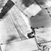
On-line Digital Images |
SC 1761045 |
RCAHMS Aerial Photography |
Oblique aerial view. |
1984 |
Item Level |
|
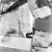 |
On-line Digital Images |
SC 1761046 |
RCAHMS Aerial Photography |
Oblique aerial view. |
1984 |
Item Level |
|
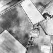 |
On-line Digital Images |
SC 1761047 |
RCAHMS Aerial Photography |
Oblique aerial view. |
1984 |
Item Level |
|
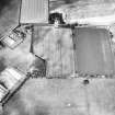 |
On-line Digital Images |
SC 1761048 |
RCAHMS Aerial Photography |
Oblique aerial view. |
1984 |
Item Level |
|
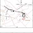 |
On-line Digital Images |
SC 1918300 |
Records of the Royal Commission on the Ancient and Historical Monuments of Scotland (RCAHMS), Edinbu |
Solway Plain landscape case-study area: maps showing the cropmarks of ploughed-out ditches forming systems of enclosures around settlements at Whinnyrig, Calvertsholm and Raeburnfoot. Publication drawing for Inventory of Eastern Dumfriesshire, generated from computer file 10CROPMK.ai. KHJM, 29 November 1996. |
1996 |
Item Level |
|
 |
On-line Digital Images |
SC 2472266 |
Records of the Ordnance Survey, Southampton, Hampshire, England |
Whinnyrig, NY36NW 30, Ordnance Survey index card, page number 1, Recto |
c. 1958 |
Item Level |
|
 |
On-line Digital Images |
SC 2472267 |
Records of the Ordnance Survey, Southampton, Hampshire, England |
Whinnyrig, NY36NW 30, Ordnance Survey index card, Recto |
c. 1958 |
Item Level |
|
 |
On-line Digital Images |
SC 2472268 |
Records of the Ordnance Survey, Southampton, Hampshire, England |
Whinnyrig, NY36NW 30, Ordnance Survey index card, Recto |
c. 1958 |
Item Level |
|
|
On-line Digital Images |
AT 003830 |
RCAHMS Aerial Transcription |
Imagery and Mapping Files for Aerial Photo Transcription. |
1/11/2012 |
Item Level |
|
|
On-line Digital Images |
AT 003831 |
RCAHMS Aerial Transcription |
Imagery and Mapping Files for Aerial Photo Transcription. |
1/11/2012 |
Item Level |
|
|
On-line Digital Images |
AT 003832 |
RCAHMS Aerial Transcription |
Imagery and Mapping Files for Aerial Photo Transcription. |
1/11/2012 |
Item Level |
|


