 |
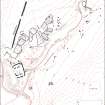
On-line Digital Images |
SC 1917419 |
Records of the Royal Commission on the Ancient and Historical Monuments of Scotland (RCAHMS), Edinbu |
Map of archaeological features in the landscape around Raeburnfoot. Published in Eastern Dumfriesshire: an archaeological landscape. |
1996 |
Item Level |
|
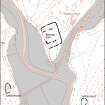 |
On-line Digital Images |
SC 1917508 |
Records of the Royal Commission on the Ancient and Historical Monuments of Scotland (RCAHMS), Edinbu |
Map of archaeological features in the landscape around Raeburnfoot. Published in Eastern Dumfriesshire: an archaeological landscape. |
1996 |
Item Level |
|
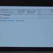 |
On-line Digital Images |
SC 2471839 |
Records of the Ordnance Survey, Southampton, Hampshire, England |
Clerk Hill, NY29NE 35, Ordnance Survey index card, Recto |
c. 1958 |
Item Level |
|


