 |
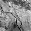
On-line Digital Images |
SC 1760984 |
RCAHMS Aerial Photography |
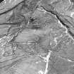
Raeburnfoot, oblique aerial view, taken from the NE, centred on a number of ring-ditches and enclosures. The course of the Roman road is visible in the top left half of the photograph. |
14/2/1996 |
Item Level |
|
 |
On-line Digital Images |
SC 1760985 |
RCAHMS Aerial Photography |
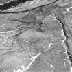
Raeburnfoot, oblique aerial view, taken from the N, centred on a number of ring-ditches and enclosures. The course of the Roman road is visible in the top half of the photograph. |
14/2/1996 |
Item Level |
|
 |
On-line Digital Images |
SC 1761008 |
RCAHMS Aerial Photography |
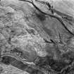
Oblique aerial view. |
1980 |
Item Level |
|
 |
On-line Digital Images |
SC 1761009 |
RCAHMS Aerial Photography |
Oblique aerial view. |
1980 |
Item Level |
|
 |
On-line Digital Images |
SC 1761010 |
RCAHMS Aerial Photography |
Oblique aerial view. |
1980 |
Item Level |
|
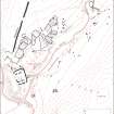 |
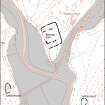
On-line Digital Images |
SC 1917419 |
Records of the Royal Commission on the Ancient and Historical Monuments of Scotland (RCAHMS), Edinbu |
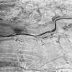
Map of archaeological features in the landscape around Raeburnfoot. Published in Eastern Dumfriesshire: an archaeological landscape. |
1996 |
Item Level |
|
 |
On-line Digital Images |
SC 1917508 |
Records of the Royal Commission on the Ancient and Historical Monuments of Scotland (RCAHMS), Edinbu |
Map of archaeological features in the landscape around Raeburnfoot. Published in Eastern Dumfriesshire: an archaeological landscape. |
1996 |
Item Level |
|
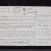 |
On-line Digital Images |
SC 2471751 |
Records of the Ordnance Survey, Southampton, Hampshire, England |
Raeburnfoot, NY29NE 1, Ordnance Survey index card, page number 1, Recto |
c. 1958 |
Item Level |
|
 |
On-line Digital Images |
SC 2471752 |
Records of the Ordnance Survey, Southampton, Hampshire, England |
Raeburnfoot, NY29NE 1, Ordnance Survey index card, page number 2, Verso |
c. 1958 |
Item Level |
|
 |
On-line Digital Images |
SC 2471753 |
Records of the Ordnance Survey, Southampton, Hampshire, England |
Raeburnfoot, NY29NE 1, Ordnance Survey index card, Recto |
c. 1958 |
Item Level |
|


