 |
On-line Digital Images |
SC 1760889 |
RCAHMS Aerial Photography |
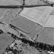
Oblique aerial view of Birrens, taken from the NE, centred on a Roman Fort. A watermill, situated to the E of the fort is visible in the bottom left-hand corner of the photograph. |
21/7/1997 |
Item Level |
|
 |
On-line Digital Images |
SC 1760890 |
RCAHMS Aerial Photography |
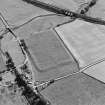
Oblique aerial view of Birrens, taken from the N, centred on a Roman Fort. A watermill, situated to the E of the fort is visible in the bottom right-hand corner of the photograph. |
21/7/1997 |
Item Level |
|
 |
On-line Digital Images |
SC 1760892 |
RCAHMS Aerial Photography |
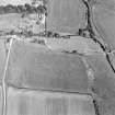
Oblique aerial view of Birrens, taken from the W, centred on a Roman Fort. A watermill, situated to the E of the fort is visible in the top left-hand corner of the photograph. |
21/7/1997 |
Item Level |
|
 |
On-line Digital Images |
SC 2471476 |
Records of the Ordnance Survey, Southampton, Hampshire, England |
Satur Mill, NY27NW 20, Ordnance Survey index card, Recto |
c. 1958 |
Item Level |
|


