 |
On-line Digital Images |
SC 1917793 |
Records of the Royal Commission on the Ancient and Historical Monuments of Scotland (RCAHMS), Edinbu |
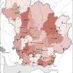
Map showing the distribution of medieval parish churches (named) in Annandale and Eskdale, against the pattern of parish boundaries at the present day. Published in Eastern Dumfriesshire: an archaeological landscape. |
1996 |
Item Level |
|
 |
On-line Digital Images |
SC 2470689 |
Records of the Ordnance Survey, Southampton, Hampshire, England |
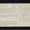
Brydekirk Mains, St Bryde's Kirk, NY17SE 8, Ordnance Survey index card, page number 1, Recto |
c. 1958 |
Item Level |
|
 |
On-line Digital Images |
SC 2470690 |
Records of the Ordnance Survey, Southampton, Hampshire, England |
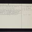
Brydekirk Mains, St Bryde's Kirk, NY17SE 8, Ordnance Survey index card, page number 2, Verso |
c. 1958 |
Item Level |
|
 |
On-line Digital Images |
SC 2470691 |
Records of the Ordnance Survey, Southampton, Hampshire, England |
Brydekirk Mains, St Bryde's Kirk, NY17SE 8, Ordnance Survey index card, Recto |
c. 1958 |
Item Level |
|


