 |
On-line Digital Images |
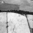
SC 503749 |
|
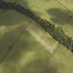
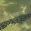
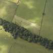
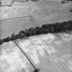
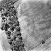
Conhuith Plantation, oblique aerial view, taken from the WNW, centred on the cropmarks of two settlement enclosures. |
|
Item Level |
|
 |
On-line Digital Images |
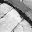
DP 011270 |
RCAHMS Aerial Photography Digital |
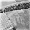
Oblique aerial view of the parchmarks of the settlement, taken from the SW. |
30/8/2005 |
Item Level |
|
 |
On-line Digital Images |
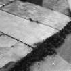
DP 011271 |
RCAHMS Aerial Photography Digital |
Oblique aerial view of the parchmarks of the settlement, taken from the ENE. |
30/8/2005 |
Item Level |
|
 |
On-line Digital Images |
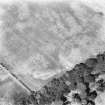
DP 011272 |
RCAHMS Aerial Photography Digital |
Oblique aerial view of the parchmarks of the settlement, taken from the NE. |
30/8/2005 |
Item Level |
|
 |
On-line Digital Images |
SC 1758322 |
RCAHMS Aerial Photography |
Conhuith Plantation, oblique aerial view, taken from the WNW, centred on the cropmarks of two settlement enclosures. |
10/7/1995 |
Item Level |
|
 |
On-line Digital Images |
SC 1758323 |
RCAHMS Aerial Photography |
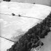
Conhuith Plantation, oblique aerial view, taken from the WSW, centred on the cropmarks of two settlement enclosures. |
10/7/1995 |
Item Level |
|
 |
On-line Digital Images |
SC 1758324 |
RCAHMS Aerial Photography |
Conhuith Plantation, oblique aerial view, taken from the ESE, centred on the cropmarks of two settlement enclosures. |
10/7/1995 |
Item Level |
|
 |
On-line Digital Images |
SC 1758337 |
RCAHMS Aerial Photography |
Oblique aerial view. |
1992 |
Item Level |
|
 |
On-line Digital Images |
SC 1758338 |
RCAHMS Aerial Photography |
Oblique aerial view. |
1992 |
Item Level |
|
 |
On-line Digital Images |
SC 1758339 |
RCAHMS Aerial Photography |
Oblique aerial view. |
1992 |
Item Level |
|
 |
On-line Digital Images |
SC 1758340 |
RCAHMS Aerial Photography |
Oblique aerial view. |
1992 |
Item Level |
|
 |
On-line Digital Images |
SC 1758412 |
RCAHMS Aerial Photography |
Oblique aerial view. |
1977 |
Item Level |
|
 |
On-line Digital Images |
SC 1758413 |
RCAHMS Aerial Photography |
Oblique aerial view. |
1977 |
Item Level |
|
 |
On-line Digital Images |
SC 1758414 |
RCAHMS Aerial Photography |
Oblique aerial view. |
1977 |
Item Level |
|
 |
On-line Digital Images |
SC 2468882 |
Records of the Ordnance Survey, Southampton, Hampshire, England |
Carruchan, Conhuith Plantation, NX97SE 24, Ordnance Survey index card, Recto |
1958 |
Item Level |
|
 |
On-line Digital Images |
SC 2468883 |
Records of the Ordnance Survey, Southampton, Hampshire, England |
Carruchan, Conhuith Plantation, NX97SE 24, Ordnance Survey index card, Recto |
1958 |
Item Level |
|
 |
On-line Digital Images |
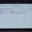
SC 2468884 |
Records of the Ordnance Survey, Southampton, Hampshire, England |
Carruchan, Conhuith Plantation, NX97SE 24, Ordnance Survey index card, Recto |
1958 |
Item Level |
|


