 |
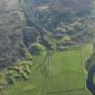
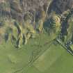
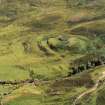
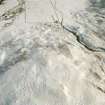
On-line Digital Images |
DP 080222 |
RCAHMS Aerial Photography Digital |
Oblique aerial view of the remains of the broch, township buildings, rig and hut-circle at Kilbraur, taken from the E. |
29/5/2009 |
Item Level |
|
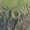 |
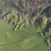
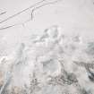
On-line Digital Images |
DP 080227 |
RCAHMS Aerial Photography Digital |
Oblique aerial view of the remains of the broch, township buildings, rig and hut-circle at Kilbraur, taken from the SW. |
29/5/2009 |
Item Level |
|
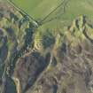 |
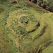
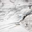
On-line Digital Images |
DP 080228 |
RCAHMS Aerial Photography Digital |
Oblique aerial view of the remains of the broch, township buildings, rig and hut-circle at Kilbraur, taken from the SW. |
29/5/2009 |
Item Level |
|
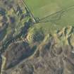 |
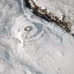
On-line Digital Images |
DP 080229 |
RCAHMS Aerial Photography Digital |
Oblique aerial view of the remains of the broch, township buildings, rig and hut-circle at Kilbraur, taken from the SSW. |
29/5/2009 |
Item Level |
|
 |
On-line Digital Images |
DP 080230 |
RCAHMS Aerial Photography Digital |
Oblique aerial view of the remains of the broch, township buildings, rig and hut-circle at Kilbraur, taken from the NE. |
29/5/2009 |
Item Level |
|
 |
On-line Digital Images |
DP 080231 |
RCAHMS Aerial Photography Digital |
Oblique aerial view of the remains of the broch, township buildings, rig and hut-circle at Kilbraur, taken from the NNE. |
29/5/2009 |
Item Level |
|
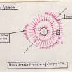 |
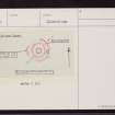
On-line Digital Images |
SC 1542083 |
Records of the Ordnance Survey, Southampton, Hampshire, England |
Plan, copied from OS '495' card |
26/4/1964 |
Item Level |
|
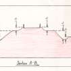 |
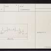
On-line Digital Images |
SC 1542084 |
Records of the Ordnance Survey, Southampton, Hampshire, England |
Section, copied from OS '495' card |
27/10/1975 |
Item Level |
|
 |
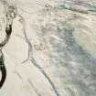
On-line Digital Images |
SC 1774449 |
John Dewar |
Oblique aerial view of the site at Kilbruar.
|
7/1972 |
Item Level |
|
 |
On-line Digital Images |
SC 1774450 |
John Dewar |
Oblique aerial view of the site at Kilbruar.
|
7/1972 |
Item Level |
|
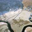 |
On-line Digital Images |
SC 1907038 |
Papers of James Sloan Bone, landscape historian, Inverness, Highland, Scotland |
Aerial view of Kilbraur, Strath Brora, East Sutherland, looking W. |
2001 |
Item Level |
|
 |
On-line Digital Images |
SC 1909775 |
Papers of James Sloan Bone, landscape historian, Inverness, Highland, Scotland |
Aerial view of Urachoile, Strath Brora, East Sutherland, looking SE. |
2001 |
Item Level |
|
 |
On-line Digital Images |
SC 1909776 |
Papers of James Sloan Bone, landscape historian, Inverness, Highland, Scotland |
Aerial view of Kilbraur Broch, Strath Brora, East Sutherland, looking E. |
2001 |
Item Level |
|
 |
On-line Digital Images |
SC 1944939 |
Papers of James Sloan Bone, landscape historian, Inverness, Highland, Scotland |
Aerial view of Kilbraur settlement remains, Strath Brora, East Sutherland, looking NE. |
13/3/2001 |
Item Level |
|
 |
On-line Digital Images |
SC 1944940 |
Papers of James Sloan Bone, landscape historian, Inverness, Highland, Scotland |
Aerial view of Kilbraur broch and Uarachoile settlement remains, Strath Brora, East Sutherland, looking SW. |
13/3/2001 |
Item Level |
|
 |
On-line Digital Images |
SC 1944941 |
Papers of James Sloan Bone, landscape historian, Inverness, Highland, Scotland |
Aerial view of Kilbraur Broch and settlement remains, Strath Brora, East Sutherland, looking W. |
13/3/2001 |
Item Level |
|
 |
On-line Digital Images |
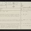
SC 2349535 |
Records of the Ordnance Survey, Southampton, Hampshire, England |
Kilbruar, NC80NW 4, Ordnance Survey index card, page number 1, Recto |
c. 1958 |
Item Level |
|
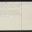 |
On-line Digital Images |
SC 2349536 |
Records of the Ordnance Survey, Southampton, Hampshire, England |
Kilbruar, NC80NW 4, Ordnance Survey index card, page number 2, Verso |
c. 1958 |
Item Level |
|
 |
On-line Digital Images |
SC 2349537 |
Records of the Ordnance Survey, Southampton, Hampshire, England |
Kilbruar, NC80NW 4, Ordnance Survey index card, Recto |
c. 1958 |
Item Level |
|
 |
On-line Digital Images |
SC 2349538 |
Records of the Ordnance Survey, Southampton, Hampshire, England |
Kilbruar, NC80NW 4, Ordnance Survey index card, Verso |
c. 1958 |
Item Level |
|
 |
On-line Digital Images |
SC 2349539 |
Records of the Ordnance Survey, Southampton, Hampshire, England |
Kilbruar, NC80NW 4, Ordnance Survey index card, Recto |
c. 1958 |
Item Level |
|


