 |
On-line Digital Images |
SC 1232874 |
|
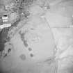
General view. |
|
Item Level |
|
 |
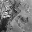
On-line Digital Images |
SC 1756490 |
RCAHMS Aerial Photography |
Oblique aerial view centred on the remains of the fort with power station and road bridge adjacent, taken from the SW. |
11/12/2000 |
Item Level |
|
 |
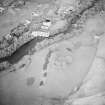
On-line Digital Images |
SC 1756510 |
RCAHMS Aerial Photography |
Oblique aerial view centred on the remains of the fort with the power station and road bridge adjacent, taken from the WSW. |
28/3/2002 |
Item Level |
|
 |
On-line Digital Images |
SC 1756579 |
RCAHMS Aerial Photography |
Oblique aerial view centred on the remains of the fort with power station and road bridge adjacent, taken from the SSW. |
11/12/2000 |
Item Level |
|
 |
On-line Digital Images |
SC 2465853 |
Records of the Ordnance Survey, Southampton, Hampshire, England |
Tongland, Old Bridge, NX65SE 89, Ordnance Survey index card, Recto |
c. 1958 |
Item Level |
|


