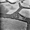
 |
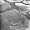
On-line Digital Images |
DP 049855 |
RCAHMS Aerial Photography Digital |
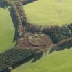
Oblique aerial view of the remains of the fort at Marygold Plantation, taken from the NNW. |
2/11/2008 |
Item Level |
|
 |
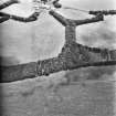
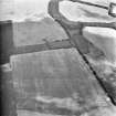
On-line Digital Images |
DP 049856 |
RCAHMS Aerial Photography Digital |
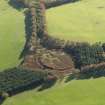
Oblique aerial view of the remains of the fort at Marygold Plantation, taken from the NW. |
2/11/2008 |
Item Level |
|
 |
On-line Digital Images |
DP 225493 |
Records of the Royal Commission on the Ancient and Historical Monuments of Scotland (RCAHMS), Edinbu |
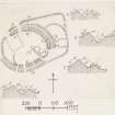
Publication drawing; plan and section, fort, Marygold Plantation. |
c. 1912 |
Item Level |
|
 |
On-line Digital Images |
DP 225497 |
Records of the Royal Commission on the Ancient and Historical Monuments of Scotland (RCAHMS), Edinbu |
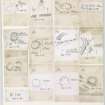
Publication drawings; 13 inked plans of sites (at a reduced scale), mounted on a single sheet. Includes Kirktonhill, Overhowden, Kelphope Burn, Longcroft, Knock Hill, Preston Cleugh, Ladykirk, Milne Garden, Ninewells, Oatlee Hill and Marygold Plantation (2). |
c. 1912 |
Item Level |
|
 |
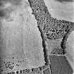
On-line Digital Images |
SC 1752754 |
RCAHMS Aerial Photography |
Oblique aerial view. |
1981 |
Item Level |
|
 |
On-line Digital Images |
SC 1752755 |
RCAHMS Aerial Photography |
Oblique aerial view. |
1981 |
Item Level |
|
 |
On-line Digital Images |
SC 1752756 |
RCAHMS Aerial Photography |
Oblique aerial view. |
1981 |
Item Level |
|
 |
On-line Digital Images |
SC 1752757 |
RCAHMS Aerial Photography |
Oblique aerial view. |
1981 |
Item Level |
|
 |
On-line Digital Images |
SC 1752758 |
RCAHMS Aerial Photography |
Oblique aerial view. |
1981 |
Item Level |
|
 |
On-line Digital Images |
SC 1752759 |
RCAHMS Aerial Photography |
Oblique aerial view. |
1981 |
Item Level |
|
 |
On-line Digital Images |
SC 1752760 |
RCAHMS Aerial Photography |
Oblique aerial view. |
1981 |
Item Level |
|
 |
On-line Digital Images |
SC 1752761 |
RCAHMS Aerial Photography |
Oblique aerial view. |
1981 |
Item Level |
|
 |
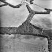
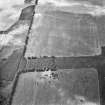
On-line Digital Images |
SC 1752850 |
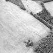
RCAHMS Aerial Photography |
Oblique aerial view centred on the remains of the fort, settlement and linear earthworks, taken from the NNE. |
30/6/2000 |
Item Level |
|
 |
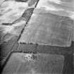
On-line Digital Images |
SC 1752851 |
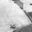
RCAHMS Aerial Photography |
Oblique aerial view centred on the remains of the fort, settlement and linear earthworks, taken from the W. |
30/6/2000 |
Item Level |
|
 |
On-line Digital Images |
SC 1752852 |
RCAHMS Aerial Photography |
Oblique aerial view centred on the remains of the fort, settlement and linear earthworks, taken from the WSW. |
30/6/2000 |
Item Level |
|
 |
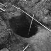
On-line Digital Images |
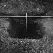
SC 1953160 |
|
Excavation photograph - pit |
1983 |
Item Level |
|
 |
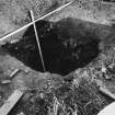
On-line Digital Images |
SC 1953161 |
|
Excavation photograph - pit |
1983 |
Item Level |
|
 |
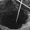
On-line Digital Images |
SC 1953162 |
|
Excavation photograph - pit |
1983 |
Item Level |
|
 |
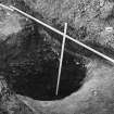
On-line Digital Images |
SC 1953163 |
|
Excavation photograph - pit |
1983 |
Item Level |
|
 |
On-line Digital Images |
SC 1953204 |
|
Excavation photograph - pit |
1983 |
Item Level |
|
 |
On-line Digital Images |
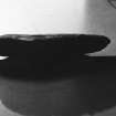
SC 1953205 |
|
Stone ard |
1983 |
Item Level |
|
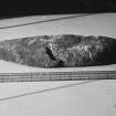 |
On-line Digital Images |
SC 1953206 |
|
Stone ard |
1983 |
Item Level |
|
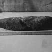 |
On-line Digital Images |
SC 1953207 |
|
Stone ard |
1983 |
Item Level |
|
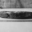 |
On-line Digital Images |
SC 1953208 |
|
Stone ard |
1983 |
Item Level |
|


