 |
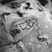
On-line Digital Images |
SC 1752422 |
RCAHMS Aerial Photography |
Oblique aerial view centred on the settlement and farmstead with the settlement and enclosure adjacent, taken from the SW. |
25/1/2001 |
Item Level |
|
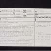 |
On-line Digital Images |
SC 2457292 |
Records of the Ordnance Survey, Southampton, Hampshire, England |
Westerside, NT86NE 9, Ordnance Survey index card, page number 1, Recto |
1958 |
Item Level |
|
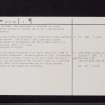 |
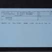
On-line Digital Images |
SC 2457293 |
Records of the Ordnance Survey, Southampton, Hampshire, England |
Westerside, NT86NE 9, Ordnance Survey index card, page number 2, Verso |
1958 |
Item Level |
|
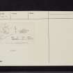 |
On-line Digital Images |
SC 2457294 |
Records of the Ordnance Survey, Southampton, Hampshire, England |
Westerside, NT86NE 9, Ordnance Survey index card, Recto |
1958 |
Item Level |
|
 |
On-line Digital Images |
SC 2457295 |
Records of the Ordnance Survey, Southampton, Hampshire, England |
Westerside, NT86NE 9, Ordnance Survey index card, Recto |
1958 |
Item Level |
|


