 |
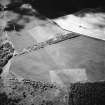
On-line Digital Images |
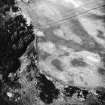
SC 1751241 |
RCAHMS Aerial Photography |
Oblique aerial view |
1986 |
Item Level |
|
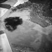 |
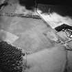
On-line Digital Images |
SC 1751369 |
RCAHMS Aerial Photography |
Oblique aerial view centred on the cropmarks of the possible pits and enclosure, taken from the SW. |
25/6/2004 |
Item Level |
|
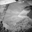 |
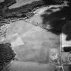
On-line Digital Images |
SC 1751370 |
RCAHMS Aerial Photography |
Oblique aerial view centred on the cropmarks of the settlement with the cropmarks adjacent, taken from the SE. |
25/6/2004 |
Item Level |
|
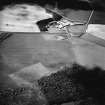 |
On-line Digital Images |
SC 1751371 |
RCAHMS Aerial Photography |
Oblique aerial view centred on the cropmarks of the possible pits and enclosure, taken from the SW. |
25/6/2004 |
Item Level |
|
 |
On-line Digital Images |
SC 1751372 |
RCAHMS Aerial Photography |
Oblique aerial view centred on the cropmarks of the settlement with the cropmarks adjacent, taken from the E. |
25/6/2004 |
Item Level |
|
 |
On-line Digital Images |
SC 1751373 |
RCAHMS Aerial Photography |
Oblique aerial view centred on the cropmarks of the possible pits and enclosure, taken from the SW. |
25/6/2004 |
Item Level |
|
 |
On-line Digital Images |
SC 1751374 |
RCAHMS Aerial Photography |
Oblique aerial view of the cropmarks of the possible pits, possible enclosure and settlement, taken from the NE. |
25/6/2004 |
Item Level |
|
|
On-line Digital Images |
AT 003519 |
Historic Environment Scotland |
Imagery and Mapping Files for Aerial Photo Transcription |
1/2/2019 |
Item Level |
|
 |
On-line Digital Images |
SC 2455730 |
Records of the Ordnance Survey, Southampton, Hampshire, England |
Springfield, NT77SE 57, Ordnance Survey index card, Recto |
c. 1958 |
Item Level |
|


