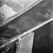
 |
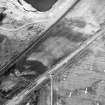
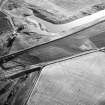
On-line Digital Images |
SC 1750520 |
RCAHMS Aerial Photography |
Dryburn Bridge, oblique aerial view, taken from the NW, centred on the cropmarks of a palisaded enclosure. |
21/7/1995 |
Item Level |
|
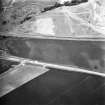
 |
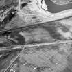
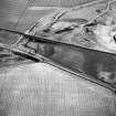
On-line Digital Images |
SC 1750521 |
RCAHMS Aerial Photography |
Dryburn Bridge, oblique aerial view, taken from the SE, centred on the cropmarks of a palisaded enclosure. |
21/7/1995 |
Item Level |
|
 |
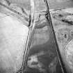
On-line Digital Images |
SC 1750522 |
RCAHMS Aerial Photography |
Dryburn Bridge, oblique aerial view, taken from the ESE, centred on the cropmarks of a palisaded enclosure. |
21/7/1995 |
Item Level |
|
 |
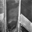
On-line Digital Images |
SC 1750523 |
RCAHMS Aerial Photography |
Dryburn Bridge, oblique aerial view, taken from the NE, centred on the cropmarks of a palisaded enclosure. |
21/7/1995 |
Item Level |
|
 |
On-line Digital Images |
SC 1750526 |
RCAHMS Aerial Photography |
Dryburn Bridge, oblique aerial view, taken from the ENE, centred on the cropmarks of a palisaded enclosure. |
2/7/1996 |
Item Level |
|
 |
On-line Digital Images |
SC 1750527 |
RCAHMS Aerial Photography |
Dryburn Bridge, oblique aerial view, taken from the NE, centred on the cropmarks of a palisaded enclosure. |
2/7/1996 |
Item Level |
|
 |
On-line Digital Images |
SC 1750528 |
RCAHMS Aerial Photography |
Dryburn Bridge, oblique aerial view, taken from the NW, centred on the cropmarks of a palisaded enclosure. |
2/7/1996 |
Item Level |
|
 |
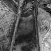
On-line Digital Images |
SC 1750633 |
RCAHMS Aerial Photography |
Oblique aerial view showing the cropmark of a palisaded enclosure (2) part of the excavation of a palisaded enclosure (1). |
1980 |
Item Level |
|
 |
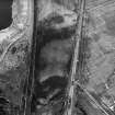
On-line Digital Images |
SC 1750634 |
RCAHMS Aerial Photography |
Oblique aerial view showing the cropmark of a palisaded enclosure (2) part of the excavation of a palisaded enclosure (1). |
1980 |
Item Level |
|
 |
On-line Digital Images |
SC 1750635 |
RCAHMS Aerial Photography |
Oblique aerial view showing the cropmark of a palisaded enclosure (2) andfthe excavation of a palisaded enclosure (1). |
1980 |
Item Level |
|
 |
On-line Digital Images |
SC 2455592 |
Records of the Ordnance Survey, Southampton, Hampshire, England |
Dryburn Bridge, NT77NW 30, Ordnance Survey index card, Recto |
c. 1958 |
Item Level |
|


