 |
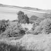
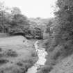
On-line Digital Images |
SC 1630105 |
List C Survey |
General view from W. |
1975 |
Item Level |
|
 |
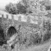
On-line Digital Images |
SC 1630106 |
List C Survey |
View at carriageway level from S. |
1975 |
Item Level |
|
 |
On-line Digital Images |
SC 1630107 |
List C Survey |
View from carriageway level showing E side elevation from N. |
1975 |
Item Level |
|
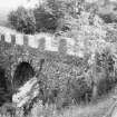 |
On-line Digital Images |
SC 1630108 |
List C Survey |
View from carriageway level showing E side elevation from N. |
1975 |
Item Level |
|
 |
On-line Digital Images |
SC 1630109 |
List C Survey |
View of E elevation from riverbank. |
1975 |
Item Level |
|
 |
On-line Digital Images |
SC 2455214 |
Records of the Ordnance Survey, Southampton, Hampshire, England |
Millburn Bridge, NT75NE 39, Ordnance Survey index card, Recto |
1958 |
Item Level |
|
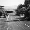 |
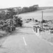
On-line Digital Images |
SC 2483543 |
|
View from road, before Preston and Chirnside turning. |
|
Item Level |
|


