 |
On-line Digital Images |
SC 1692927 |
RCAHMS Aerial Photography |
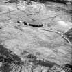
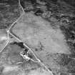
Cnoc Achad na h-Uaighe, East Langwell, oblique aerial view, taken from the N, centred on an area defined as an archaeological landscape, hut-circles, small cairns and a builidng. The remains of two buildings, fields banks and small cairns are visible in the top left-hand corner of the photograph. |
13/6/1995 |
Item Level |
|
 |
On-line Digital Images |
SC 1692928 |
RCAHMS Aerial Photography |
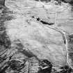
Cnoc Achad na h-Uaighe, East Langwell, oblique aerial view, taken from the NNW, centred on an area defined as an archaeological landscape, small cairns, hut-circles and a building. The remains of two buildings, fieldbanks and small cairns is visible in the upper right-hand corner, as well as an area with small cairns in the upper left-hand corner. |
13/6/1995 |
Item Level |
|
 |
On-line Digital Images |
SC 1692929 |
RCAHMS Aerial Photography |
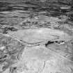
Cnoc Achad na h-Uaighe, Achnahuie, oblique aerial view, taken from the SW, showing an area defined as an archaeological landscape, various hut-circles, huts, small cairns and the remains of a building. |
13/6/1995 |
Item Level |
|
 |
On-line Digital Images |
SC 1692930 |
RCAHMS Aerial Photography |
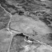
Cnoc Achad na h-Uaighe, Achnahuie, oblique aerial view, taken from the S, showing an area defined as an archaeological landscape, various hut-circles, huts, small cairns and the remains of a building. |
13/6/1995 |
Item Level |
|
 |
On-line Digital Images |
SC 1692931 |
RCAHMS Aerial Photography |
Cnoc Achad na h-Uaighe, Achnahuie, oblique aerial view, taken from the SE, centred on an area defined as an archaeological landscape, an area with a hut-circle, small cairns, lynchets and a possible hut and the remains of a building. Hut-circles and a hut are visible in the upper left-hand corner. |
13/6/1995 |
Item Level |
|
 |
On-line Digital Images |
SC 2348473 |
Records of the Ordnance Survey, Southampton, Hampshire, England |
Cnoc Achadh Na H-Uaighe, NC70NW 2, Ordnance Survey index card, page number 1, Recto |
1958 |
Item Level |
|
 |
On-line Digital Images |
SC 2348474 |
Records of the Ordnance Survey, Southampton, Hampshire, England |
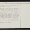
Cnoc Achadh Na H-Uaighe, NC70NW 2, Ordnance Survey index card, page number 2, Verso |
1958 |
Item Level |
|
 |
On-line Digital Images |
SC 2348475 |
Records of the Ordnance Survey, Southampton, Hampshire, England |
Cnoc Achadh Na H-Uaighe, NC70NW 2, Ordnance Survey index card, page number 3, Recto |
1958 |
Item Level |
|
 |
On-line Digital Images |
SC 2348476 |
Records of the Ordnance Survey, Southampton, Hampshire, England |
Cnoc Achadh Na H-Uaighe, NC70NW 2, Ordnance Survey index card, page number 4, Verso |
1958 |
Item Level |
|


