 |
On-line Digital Images |
SC 1745999 |
RCAHMS Aerial Photography |
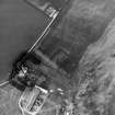
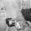
Whitelaw, oblique aerial view, taken from the SSW, centred on the cropmarks of an enclosure adjacent to a farmhouse and farmsteading. |
9/7/1996 |
Item Level |
|
 |
On-line Digital Images |
SC 1746050 |
RCAHMS Aerial Photography |
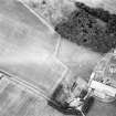
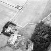
Oblique aerial view. |
1979 |
Item Level |
|
 |
On-line Digital Images |
SC 1746051 |
RCAHMS Aerial Photography |
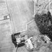
Oblique aerial view. |
1979 |
Item Level |
|
 |
On-line Digital Images |
SC 1746052 |
RCAHMS Aerial Photography |
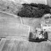
Oblique aerial view. |
1979 |
Item Level |
|
 |
On-line Digital Images |
SC 1746053 |
RCAHMS Aerial Photography |
Oblique aerial view. |
1979 |
Item Level |
|
 |
On-line Digital Images |
SC 1746054 |
RCAHMS Aerial Photography |
Oblique aerial view. |
1979 |
Item Level |
|
 |
On-line Digital Images |
SC 2451123 |
Records of the Ordnance Survey, Southampton, Hampshire, England |
Whitelaw, NT57SE 46, Ordnance Survey index card, Recto |
c. 1958 |
Item Level |
|


