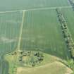
 |
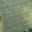
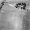
On-line Digital Images |
DP 216697 |
RCAHMS Aerial Photography Digital |
Oblique aerial view of the cropmarks of the ring ditch, looking E. |
9/7/2015 |
Item Level |
|
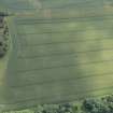 |
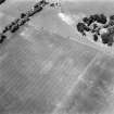
On-line Digital Images |
DP 216698 |
RCAHMS Aerial Photography Digital |
Oblique aerial view of the cropmarks of the ring ditch, looking ENE. |
9/7/2015 |
Item Level |
|
 |
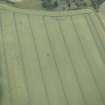
On-line Digital Images |
DP 217356 |
RCAHMS Aerial Photography Digital |
Oblique aerial view of the cropmarks of the ring ditch, looking NW. |
12/6/2015 |
Item Level |
|
 |
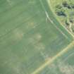
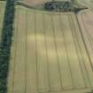
On-line Digital Images |
DP 217357 |
RCAHMS Aerial Photography Digital |
Oblique aerial view of the cropmarks of the ring ditch, looking SW. |
12/6/2015 |
Item Level |
|
 |
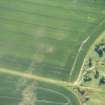
On-line Digital Images |
DP 217358 |
RCAHMS Aerial Photography Digital |
Oblique aerial view of the cropmarks of the ring ditch, looking SSE. |
12/6/2015 |
Item Level |
|
 |
On-line Digital Images |
DP 217555 |
RCAHMS Aerial Photography Digital |
Oblique aerial view of the location of the ring ditch under crop but with no visible cropmarking, looking N. |
22/7/2015 |
Item Level |
|
 |
On-line Digital Images |
DP 218164 |
RCAHMS Aerial Photography Digital |
Oblique aerial view of the site of the ring ditch, looking NNW. |
6/8/2015 |
Item Level |
|
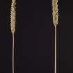 |
On-line Digital Images |
DP 248070 |
Historic Environment Scotland |
Barley heads collected from outside the ring ditch (left) and inside the ring ditch (right) |
7/2015 |
Item Level |
|
 |
On-line Digital Images |
SC 1744671 |
RCAHMS Aerial Photography |
Oblique aerial view |
1980 |
Item Level |
|
 |
On-line Digital Images |
SC 1744672 |
RCAHMS Aerial Photography |
Oblique aerial view |
1980 |
Item Level |
|
|
On-line Digital Images |
AT 003489 |
Historic Environment Scotland |
Imagery and Mapping Files for Aerial Photo Transcription |
14/3/2019 |
Item Level |
|
 |
On-line Digital Images |
SC 2450927 |
Records of the Ordnance Survey, Southampton, Hampshire, England |
Amisfield Mains, NT57NW 67, Ordnance Survey index card, Recto |
c. 1958 |
Item Level |
|


