 |
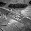
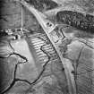
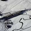
On-line Digital Images |
SC 1002835 |
RCAHMS Aerial Photography |
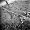
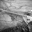
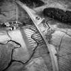
Oblique aerial view from N centred on the Shankend Railway Viaduct. Surveyed by RCAHMS as part of the Waverley Line Project during May 2010. |
1981 |
Item Level |
|
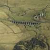 |
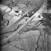
On-line Digital Images |
DP 026895 |
RCAHMS Aerial Photography Digital |
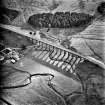
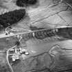
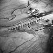
Oblique aerial view centred on viaduct and Shankend Farm, taken from the SW. |
2/3/2007 |
Item Level |
|
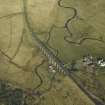 |
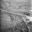
On-line Digital Images |
DP 026896 |
RCAHMS Aerial Photography Digital |
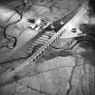
Oblique aerial view centred on viaduct and Shankend Farm, taken from the S. |
2/3/2007 |
Item Level |
|
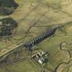 |
On-line Digital Images |
DP 026897 |
RCAHMS Aerial Photography Digital |
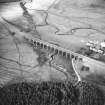
Oblique aerial view centred on viaduct and Shankend Farm, taken from the E. |
2/3/2007 |
Item Level |
|
 |
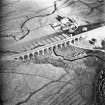
On-line Digital Images |
SC 1668668 |
RCAHMS Aerial Photography |
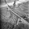
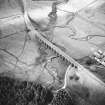
Oblique aerial view from S. |
1981 |
Item Level |
|
 |
On-line Digital Images |
SC 1668669 |
RCAHMS Aerial Photography |
Oblique aerial view from S. |
1981 |
Item Level |
|
 |
On-line Digital Images |
SC 1668670 |
RCAHMS Aerial Photography |
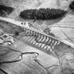
Oblique aerial view from NE. |
1981 |
Item Level |
|
 |
On-line Digital Images |
SC 1668671 |
RCAHMS Aerial Photography |
Oblique aerial view from N. |
1981 |
Item Level |
|
 |
On-line Digital Images |
SC 1668672 |
RCAHMS Aerial Photography |
Oblique aerial view from NW. |
1981 |
Item Level |
|
 |
On-line Digital Images |
SC 1668673 |
RCAHMS Aerial Photography |
Oblique aerial view from W. |
1981 |
Item Level |
|
 |
On-line Digital Images |
SC 1668674 |
RCAHMS Aerial Photography |
Oblique aerial view from W. |
1981 |
Item Level |
|
 |
On-line Digital Images |
SC 1668675 |
RCAHMS Aerial Photography |
Oblique aerial view from SW. |
1981 |
Item Level |
|
 |
On-line Digital Images |
SC 1740978 |
RCAHMS Aerial Photography |
Oblique aerial view from S. |
1981 |
Item Level |
|
 |
On-line Digital Images |
SC 1740979 |
RCAHMS Aerial Photography |
Oblique aerial view from S. |
1981 |
Item Level |
|
 |
On-line Digital Images |
SC 1740980 |
RCAHMS Aerial Photography |
Oblique aerial view from NE. |
1981 |
Item Level |
|
 |
On-line Digital Images |
SC 1740981 |
RCAHMS Aerial Photography |
Oblique aerial view from N. |
1981 |
Item Level |
|
 |
On-line Digital Images |
SC 1740982 |
RCAHMS Aerial Photography |
Oblique aerial view from NW. |
1981 |
Item Level |
|
 |
On-line Digital Images |
SC 1740983 |
RCAHMS Aerial Photography |
Oblique aerial view from W. |
1981 |
Item Level |
|
 |
On-line Digital Images |
SC 1740984 |
RCAHMS Aerial Photography |
Oblique aerial view from W. |
1981 |
Item Level |
|
 |
On-line Digital Images |
SC 1740985 |
RCAHMS Aerial Photography |
Oblique aerial view from SW. |
1981 |
Item Level |
|
 |
On-line Digital Images |
SC 1938879 |
John Dent |
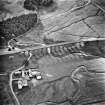
Oblique aerial view from NE. |
1991 |
Item Level |
|
 |
On-line Digital Images |
SC 2448774 |
Records of the Ordnance Survey, Southampton, Hampshire, England |
Shankend, NT50NW 30, Ordnance Survey index card, Recto |
c. 1958 |
Item Level |
|


