 |
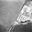
On-line Digital Images |
SC 1739379 |
RCAHMS Aerial Photography |
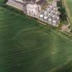
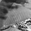
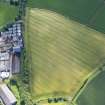
Oblique aerial view centred on the cropmarks of the fort with maltings adjacent, taken from the SSE. |
14/6/2000 |
Item Level |
|
 |
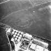
On-line Digital Images |
SC 1739380 |
RCAHMS Aerial Photography |
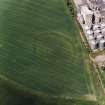
Oblique aerial view centred on the cropmarks of the fort with maltings adjacent, taken from the ESE. |
14/6/2000 |
Item Level |
|
 |
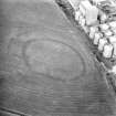
On-line Digital Images |
SC 1739381 |
RCAHMS Aerial Photography |
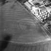
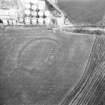
Oblique aerial view centred on the cropmarks of the fort with enclosure and maltings adjacent, taken from the SE. |
14/6/2000 |
Item Level |
|
 |
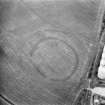
On-line Digital Images |
SC 1739382 |
RCAHMS Aerial Photography |
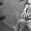
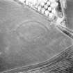
Oblique aerial view centred on the cropmarks of the fort with enclosure and maltings adjacent, taken from the E. |
14/6/2000 |
Item Level |
|
 |
On-line Digital Images |
SC 1739383 |
RCAHMS Aerial Photography |
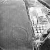
Oblique aerial view centred on the cropmarks of the fort with maltings adjacent, taken from the NE. |
14/6/2000 |
Item Level |
|
 |
On-line Digital Images |
SC 1739395 |
RCAHMS Aerial Photography |
Oblique aerial view. |
1979 |
Item Level |
|
 |
On-line Digital Images |
SC 1739396 |
RCAHMS Aerial Photography |
Oblique aerial view. |
1979 |
Item Level |
|
 |
On-line Digital Images |
SC 1739397 |
RCAHMS Aerial Photography |
Oblique aerial view |
1979 |
Item Level |
|
 |
On-line Digital Images |
SC 1739398 |
RCAHMS Aerial Photography |
Oblique aerial view. |
1979 |
Item Level |
|
 |
On-line Digital Images |
SC 1739413 |
RCAHMS Aerial Photography |
Oblique aerial view. |
1980 |
Item Level |
|
 |
On-line Digital Images |
SC 1739414 |
RCAHMS Aerial Photography |
Oblique aerial view. |
1980 |
Item Level |
|
 |
On-line Digital Images |
SC 1739415 |
RCAHMS Aerial Photography |
Oblique aerial view. |
1980 |
Item Level |
|
 |
On-line Digital Images |
DP 281168 |
Historic Environment Scotland |
Oblique aerial view. |
21/6/2018 |
Item Level |
|
 |
On-line Digital Images |
SC 2448084 |
Records of the Ordnance Survey, Southampton, Hampshire, England |
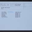
Wester Pencaitland, NT46NW 39, Ordnance Survey index card, Recto |
c. 1958 |
Item Level |
|


