 |
On-line Digital Images |
SC 1737010 |
RCAHMS Aerial Photography |
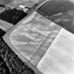
Oblique aerial view. |
1992 |
Item Level |
|
 |
On-line Digital Images |
SC 1737012 |
RCAHMS Aerial Photography |
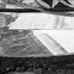
Oblique aerial view. |
1992 |
Item Level |
|
 |
On-line Digital Images |
SC 1737013 |
RCAHMS Aerial Photography |
Oblique aerial view. |
1992 |
Item Level |
|
 |
On-line Digital Images |
SC 1737014 |
RCAHMS Aerial Photography |
Oblique aerial view. |
1992 |
Item Level |
|
 |
On-line Digital Images |
SC 1737015 |
RCAHMS Aerial Photography |
Oblique aerial view. |
1992 |
Item Level |
|
 |
On-line Digital Images |
SC 1737016 |
RCAHMS Aerial Photography |
Oblique aerial view. |
1992 |
Item Level |
|
 |
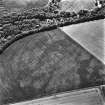
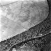
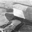
On-line Digital Images |
SC 1737032 |
RCAHMS Aerial Photography |
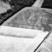
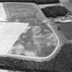
East Field, Inveresk, oblique aerial view, taken from the SW, centred on a series of cropmarks and showing a pit alignment in the centre right of the photograph. |
26/6/1995 |
Item Level |
|
 |
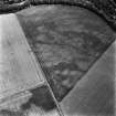
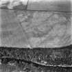
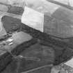
On-line Digital Images |
SC 1737033 |
RCAHMS Aerial Photography |
East Field, Inveresk, oblique aerial view, taken from the SE, centred on a series of cropmarks including a pit alignment. |
26/6/1995 |
Item Level |
|
 |
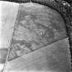
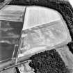
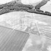
On-line Digital Images |
SC 1737034 |
RCAHMS Aerial Photography |
East Field, Inveresk, oblique aerial view, taken from the ESE, centred on a series of cropmarks including a pit alignment. |
26/6/1995 |
Item Level |
|
 |
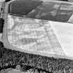
On-line Digital Images |
SC 1737048 |
RCAHMS Aerial Photography |
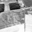
East Field, Inveresk, oblique aerial view, taken from the SE, centred on the cropmarks of a pit-alignment and pits. A pair of parallel pit-alignments and further cropmarks are visible in the centre left of the photograph. |
27/6/1996 |
Item Level |
|
 |
On-line Digital Images |
SC 1737049 |
RCAHMS Aerial Photography |
East Field, Inveresk, oblique aerial view, taken from the N, centred on the cropmarks of a pit-alignment and pits. |
27/6/1996 |
Item Level |
|
 |
On-line Digital Images |
SC 1737050 |
RCAHMS Aerial Photography |
East Field, Inveresk, oblique aerial view, taken from the NNE, centred on the cropmarks of a pit-alignment and pits. |
27/6/1996 |
Item Level |
|
 |
On-line Digital Images |
SC 1737051 |
RCAHMS Aerial Photography |
East Field, Inveresk, oblique aerial view, taken from the NE, centred on the cropmarks of a pit-alignment and pits. |
27/6/1996 |
Item Level |
|
 |
On-line Digital Images |
SC 1737480 |
RCAHMS Aerial Photography |
East Field, Inveresk, oblique aerial view, taken from the NW, centred on the cropmarks of a pair of parallel pit-alignments, an enclosure and cultivation remains. Cropmarks of a pit-alignment and pits are visible in the top
half of the photograph. |
27/6/1996 |
Item Level |
|
 |
On-line Digital Images |
SC 1737481 |
RCAHMS Aerial Photography |
East Field, Inveresk, oblique aerial view, taken from the NW, centred on the cropmarks of a pair of parallel pit-alignments, an enclosure and cultivation remains. Cropmarks of a pit-alignment and pits are visible in the top
half of the photograph. |
27/6/1996 |
Item Level |
|
 |
On-line Digital Images |
SC 1737482 |
RCAHMS Aerial Photography |
East Field, Inveresk, oblique aerial view, taken from the N, centred on the cropmarks of a pair of parallel pit-alignments, an enclosure and cultivation remains. Cropmarks of further pits are visible in the top half of the photograph. |
27/6/1996 |
Item Level |
|
 |
On-line Digital Images |
SC 1737534 |
RCAHMS Aerial Photography |
Oblique aerial view. |
1979 |
Item Level |
|
 |
On-line Digital Images |
SC 1737535 |
RCAHMS Aerial Photography |
Oblique aerial view. |
1979 |
Item Level |
|
 |
On-line Digital Images |
SC 1737546 |
RCAHMS Aerial Photography |
Oblique aerial view. |
1979 |
Item Level |
|
 |
On-line Digital Images |
SC 2446408 |
Records of the Ordnance Survey, Southampton, Hampshire, England |
East Field, Inveresk, NT37SW 179, Ordnance Survey index card, Recto |
1958 |
Item Level |
|
 |
On-line Digital Images |
SC 2616492 |
Records of the Ordnance Survey, Southampton, Hampshire, England |
East Field, Inveresk, NT37S 179, Ordnance Survey index card, Recto |
1958 |
Item Level |
|


