 |
On-line Digital Images |
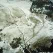
SC 993165 |
RCAHMS Aerial Photography |
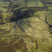
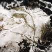
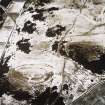
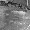
Scanned image of oblique aerial view of Castle Knowe in the Pentland Hills, centred on the remains of the trenches with the palisaded settlement and rig adjacent, taken from the SSW. |
9/2/2004 |
Item Level |
|
 |
On-line Digital Images |
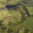
DP 012040 |
RCAHMS Aerial Photography Digital |
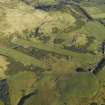
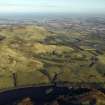
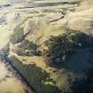
Oblique aerial view centred on the remains of the palisaded settlement, cultivation terraces and rig, taken from the SW. |
17/11/2005 |
Item Level |
|
 |
On-line Digital Images |
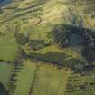
DP 012041 |
RCAHMS Aerial Photography Digital |
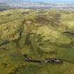
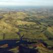
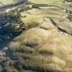
General oblique aerial view centred on the remains of the palisaded settlement, cultivation terraces, fort and rig with the rifle ranges adjacent, taken from the ESE. |
17/11/2005 |
Item Level |
|
 |
On-line Digital Images |
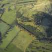
DP 012042 |
RCAHMS Aerial Photography Digital |
General oblique aerial view centred on the remains of the palisaded settlement, cultivation terraces, fort and rig with the rifle ranges, farmhouse and farmsteading adjacent, taken from the ENE. |
17/11/2005 |
Item Level |
|
 |
On-line Digital Images |
DP 012043 |
RCAHMS Aerial Photography Digital |
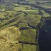
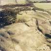
General oblique aerial view centred on the remains of the rig and field banks with the remains of the palisaded settlement in the distance, taken from the W. |
17/11/2005 |
Item Level |
|
 |
On-line Digital Images |
DP 012044 |
RCAHMS Aerial Photography Digital |
General oblique aerial view centred on the rifle ranges with the farmhouse and farmsteading and remains of the rig, fort, cultivation terraces and palisaded settlement adjacent, taken from the SW. |
17/11/2005 |
Item Level |
|
 |
On-line Digital Images |
DP 012045 |
RCAHMS Aerial Photography Digital |
General oblique aerial view centred on the rifle ranges, farmhouse and farmsteading and the remains of the rig, fort, cultivation terraces and palisaded settlement, taken from the SE. |
17/11/2005 |
Item Level |
|
 |
On-line Digital Images |
DP 012046 |
RCAHMS Aerial Photography Digital |
General oblique aerial view centred on the rifle ranges with the farmhouse and farmsteading and remains of the rig, fort, cultivation terraces and palisaded settlement adjacent, taken from the WNW. |
17/11/2005 |
Item Level |
|
 |
On-line Digital Images |
DP 012047 |
RCAHMS Aerial Photography Digital |
General oblique aerial view centred on the rifle ranges, farmhouse and farmsteading and the remains of the rig, fort, cultivation terraces and palisaded settlement, taken from the SW. |
17/11/2005 |
Item Level |
|
 |
On-line Digital Images |
DP 012048 |
RCAHMS Aerial Photography Digital |
General oblique aerial view centred on the rifle ranges, farmhouse and farmsteading and the remains of the rig, fort, cultivation terraces and palisaded settlement, taken from the SW. |
17/11/2005 |
Item Level |
|
 |
On-line Digital Images |
SC 1734180 |
RCAHMS Aerial Photography |
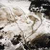
Oblique aerial view centred on the remains of the trenches with the palisaded settlement and rig adjacent, taken from the SW. |
9/2/2004 |
Item Level |
|
 |
On-line Digital Images |
SC 1734181 |
RCAHMS Aerial Photography |
Oblique aerial view centred on the remains of the trenches with the palisaded settlement and rig adjacent, taken from the SSW. |
9/2/2004 |
Item Level |
|
 |
On-line Digital Images |
SC 1734182 |
RCAHMS Aerial Photography |
Oblique aerial view of the trenches, fort, palisaded settlement and rig, taken from the SE. |
9/2/2004 |
Item Level |
|
 |
On-line Digital Images |
SC 1734190 |
RCAHMS Aerial Photography |
Oblique aerial view of trenches, with fort in the background, taken from NE. |
17/11/2005 |
Item Level |
|
 |
On-line Digital Images |
SC 1734191 |
RCAHMS Aerial Photography |
Oblique aerial view of trenches, palisaded settlement and rig, taken from N. |
17/11/2005 |
Item Level |
|
 |
On-line Digital Images |
SC 1734192 |
RCAHMS Aerial Photography |
Oblique aerial view of trenches, palisaded settlement and rig, taken from NW. |
17/11/2005 |
Item Level |
|
 |
On-line Digital Images |
SC 1734211 |
RCAHMS Aerial Photography |
Aerial view |
1981 |
Item Level |
|
 |
On-line Digital Images |
SC 2151062 |
Records of the Royal Commission on the Ancient and Historical Monuments of Scotland (RCAHMS), Edinbu |
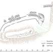
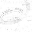
Castle Knowe palisaded settlement, 1:1000 plan |
31/7/2006 |
Item Level |
|
 |
On-line Digital Images |
SC 2151758 |
Records of the Royal Commission on the Ancient and Historical Monuments of Scotland (RCAHMS), Edinbu |
Castle Knowe palisaded settlement, 1:300 plan |
21/8/1982 |
Item Level |
|
 |
On-line Digital Images |
SC 2442697 |
Records of the Ordnance Survey, Southampton, Hampshire, England |
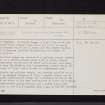
Castle Knowe, NT26SW 21, Ordnance Survey index card, page number 1, Recto |
c. 1958 |
Item Level |
|
 |
On-line Digital Images |
SC 2442698 |
Records of the Ordnance Survey, Southampton, Hampshire, England |
Castle Knowe, NT26SW 21, Ordnance Survey index card, page number 2, Verso |
c. 1958 |
Item Level |
|
 |
On-line Digital Images |
SC 2442699 |
Records of the Ordnance Survey, Southampton, Hampshire, England |
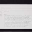
Castle Knowe, NT26SW 21, Ordnance Survey index card, Recto |
c. 1958 |
Item Level |
|
 |
On-line Digital Images |
SC 2442700 |
Records of the Ordnance Survey, Southampton, Hampshire, England |
Castle Knowe, NT26SW 21, Ordnance Survey index card, Recto |
c. 1958 |
Item Level |
|
 |
On-line Digital Images |
SC 2442701 |
Records of the Ordnance Survey, Southampton, Hampshire, England |
Castle Knowe, NT26SW 21, Ordnance Survey index card, Recto |
c. 1958 |
Item Level |
|


