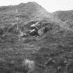
 |
On-line Digital Images |
SC 1923774 |
|
Summit of promontory, hut foundations, parapet to left |
1971 |
Item Level |
|
 |
On-line Digital Images |
SC 1923775 |
|
Summit of promontory, hut foundations, parapet to left |
1971 |
Item Level |
|
 |
On-line Digital Images |
SC 1923776 |
|
Summit of promontory, hut foundations, parapet to right |
1971 |
Item Level |
|
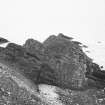
 |
On-line Digital Images |
SC 1923777 |
|
Seaward slope of promontory |
1971 |
Item Level |
|
 |
On-line Digital Images |
SC 1923778 |
|
Hut foundations at summit of promontory, parapet to right |
1971 |
Item Level |
|
 |
On-line Digital Images |
SC 1923779 |
|
Uppermost hut foundation on promontory |
1971 |
Item Level |
|
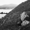
 |
On-line Digital Images |
SC 1923780 |
|
Promontory from South |
1971 |
Item Level |
|
 |
On-line Digital Images |
SC 1923781 |
|
Promontory from South West |
1971 |
Item Level |
|
 |
On-line Digital Images |
SC 1923782 |
|
Promontory from South East |
1971 |
Item Level |
|
 |
On-line Digital Images |
SC 1923794 |
|
Promontory from West |
1971 |
Item Level |
|
 |
On-line Digital Images |
SC 2346946 |
Records of the Ordnance Survey, Southampton, Hampshire, England |
Aodann Mhor, NC46NW 5, Ordnance Survey index card, page number 1, Recto |
c. 1958 |
Item Level |
|
 |
On-line Digital Images |
SC 2346947 |
Records of the Ordnance Survey, Southampton, Hampshire, England |
Aodann Mhor, NC46NW 5, Ordnance Survey index card, Recto |
c. 1958 |
Item Level |
|
 |
On-line Digital Images |
SC 2346948 |
Records of the Ordnance Survey, Southampton, Hampshire, England |
Aodann Mhor, NC46NW 5, Ordnance Survey index card, Recto |
c. 1958 |
Item Level |
|


