 |
On-line Digital Images |
SC 2437779 |
Records of the Ordnance Survey, Southampton, Hampshire, England |
Charlestown Harbour, NT08SE 31, Ordnance Survey index card, Recto |
1958 |
Item Level |
|
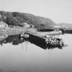 |
On-line Digital Images |
SC 2505351 |
|
Old pier from South West |
1967 |
Item Level |
|
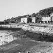 |
On-line Digital Images |
SC 2505359 |
|
Exterior of old pier from East |
1966 |
Item Level |
|
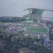 |
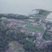
On-line Digital Images |
SC 2698884 |
RCAHMS Aerial Photography |
Oblique aerial view of Charlestown Village and Harbour taken from the N |
8/5/1998 |
Item Level |
|
 |
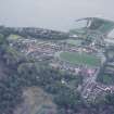
On-line Digital Images |
SC 2698885 |
RCAHMS Aerial Photography |
Oblique aerial view of Charlestown Village and Harbour taken from the NNW |
8/5/1998 |
Item Level |
|
 |
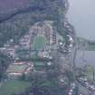
On-line Digital Images |
SC 2698886 |
RCAHMS Aerial Photography |
Oblique aerial view of Charlestown Village and Harbour taken from the N |
8/5/1998 |
Item Level |
|
 |
On-line Digital Images |
SC 2698888 |
RCAHMS Aerial Photography |
Oblique aerial view of Charlestown Village, Harbour and the remains of limekilns taken from the W |
8/5/1998 |
Item Level |
|
|
Manuscripts |
MS 2307/2 |
Historic Scotland Archive Project |
Survey archive: Site record sheets from Coastal Assessment Survey for Historic Scotland, Kincardine to Fifeness.
Parcels 8 (MS 2307/2/8), 17 (MS 2307/2/17) and 18 (MS 2307/2/18) not included with archive. |
4/1996 |
Batch Level |
|


