 |
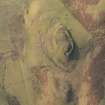
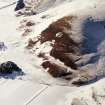
On-line Digital Images |
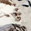
DP 208947 |
RCAHMS Aerial Photography Digital |
Oblique aerial view of the settlements, enclosure and rig at Richie Ferry, looking W. |
18/11/2014 |
Item Level |
|
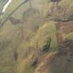 |
On-line Digital Images |
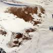
DP 208948 |
RCAHMS Aerial Photography Digital |
Oblique aerial view of the settlements, enclosure and rig at Richie Ferry, looking SW. |
18/11/2014 |
Item Level |
|
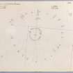 |
On-line Digital Images |
DP 234535 |
Records of the Royal Commission on the Ancient and Historical Monuments of Scotland (RCAHMS), Edinbu |
Plane table survey of Richie Ferry enclosure. |
20/8/1968 |
Item Level |
|
 |
On-line Digital Images |
DP 234536 |
Records of the Royal Commission on the Ancient and Historical Monuments of Scotland (RCAHMS), Edinbu |
Publication plan of Richie Ferry enclosure, based on 1968 survey. |
12/2/1974 |
Item Level |
|
 |
On-line Digital Images |
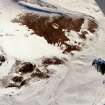
SC 1727679 |
RCAHMS Aerial Photography |
Oblique aerial view centred on the remains of the settlements, rig, enclosure and possible cultivation terraces, taken from the W. |
28/2/2001 |
Item Level |
|
 |
On-line Digital Images |
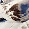
SC 1727680 |
RCAHMS Aerial Photography |
Oblique aerial view centred on the remains of the settlements, rig and enclosure with the remains of the forts adjacent, taken from the SSW. |
28/2/2001 |
Item Level |
|
 |
On-line Digital Images |
SC 1727681 |
RCAHMS Aerial Photography |
Oblique aerial view centred on the remains of the settlements, rig and enclosure with the remains of the forts adjacent, taken from the SSW. |
28/2/2001 |
Item Level |
|
 |
On-line Digital Images |
SC 1727682 |
RCAHMS Aerial Photography |
Oblique aerial view centred on the remains of the settlements, rig, enclosure and cultivation terraces, taken from the SSE. |
28/2/2001 |
Item Level |
|
 |
On-line Digital Images |
SC 1727684 |
RCAHMS Aerial Photography |
Oblique aerial view centred on the remains of the forts and enclosures with the remains of the settlements, rig, possible cultivation terraces and enclosure adjacent, taken from the E. |
28/2/2001 |
Item Level |
|
 |
On-line Digital Images |
SC 1727685 |
RCAHMS Aerial Photography |
Oblique aerial view centred on the remains of the forts and enclosures with the remains of the settlements, rig, possible cultivation terraces and enclosure adjacent, taken from the E. |
28/2/2001 |
Item Level |
|
 |
On-line Digital Images |
SC 2433487 |
Records of the Ordnance Survey, Southampton, Hampshire, England |
Richie Ferry, NS92SW 21, Ordnance Survey index card, page number 1, Recto |
c. 1958 |
Item Level |
|
 |
On-line Digital Images |
SC 2433488 |
Records of the Ordnance Survey, Southampton, Hampshire, England |
Richie Ferry, NS92SW 21, Ordnance Survey index card, page number 2, Recto |
c. 1958 |
Item Level |
|
 |
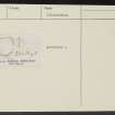
On-line Digital Images |
SC 2433489 |
Records of the Ordnance Survey, Southampton, Hampshire, England |
Richie Ferry, NS92SW 21, Ordnance Survey index card, Recto |
c. 1958 |
Item Level |
|
 |
On-line Digital Images |
SC 2433490 |
Records of the Ordnance Survey, Southampton, Hampshire, England |
Richie Ferry, NS92SW 21, Ordnance Survey index card, Recto |
c. 1958 |
Item Level |
|


