 |
On-line Digital Images |
SC 2480455 |
Records of the Ordnance Survey, Southampton, Hampshire, England |
Bonnybridge Industrial Estate, Roman Road without Margary Number, NS87NW RRX 505, Ordnance Survey index card, Recto |
c. 1958 |
Item Level |
|
 |
On-line Digital Images |
SC 2480456 |
Records of the Ordnance Survey, Southampton, Hampshire, England |
Underwood Lock, Roman Road without Margary Number, NS87NW RRX 505, Ordnance Survey index card, Recto |
c. 1958 |
Item Level |
|
 |
On-line Digital Images |
SC 2480457 |
Records of the Ordnance Survey, Southampton, Hampshire, England |
Underwood Lock, Roman Road without Margary Number, NS87NW RRX 505, Ordnance Survey index card, Recto |
c. 1958 |
Item Level |
|
 |
On-line Digital Images |
DP 402081 |
Historic Environment Scotland |
The Antonine Wall, Bonnyside East, Geophysical Survey |
22/7/2022 |
Item Level |
|
 |
On-line Digital Images |
DP 402082 |
Historic Environment Scotland |
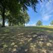
The Antonine Wall, Bonnyside East, Geophysical Survey |
22/7/2022 |
Item Level |
|