 |
On-line Digital Images |
DP 249996 |
Records of the Royal Commission on the Ancient and Historical Monuments of Scotland (RCAHMS), Edinbu |
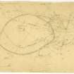
Plane table survey of fort and settlement at Black Hill. |
9/6/1955 |
Item Level |
|
 |
On-line Digital Images |
DP 253255 |
Historic Environment Scotland |
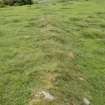
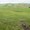
A later and ruinous boundary wall crossing the interior of the fort at the N |
30/5/2017 |
Item Level |
|
 |
On-line Digital Images |
DP 253256 |
Historic Environment Scotland |
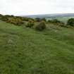
The wall of the fort at the N, surmounted by field clearance |
30/5/2017 |
Item Level |
|
 |
On-line Digital Images |
DP 253260 |
Historic Environment Scotland |
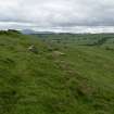
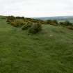
A later boundary wall and associated ditch as they cross the interior of the fort, immediately E of the cairn |
30/5/2017 |
Item Level |
|
 |
On-line Digital Images |
DP 253262 |
Historic Environment Scotland |
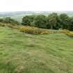
A later boundary wall crossing the interior of the fort |
30/5/2017 |
Item Level |
|
 |
On-line Digital Images |
DP 253263 |
Historic Environment Scotland |
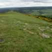
The ruinous wall of the fort along its SW side |
30/5/2017 |
Item Level |
|
 |
On-line Digital Images |
DP 253264 |
Historic Environment Scotland |
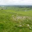
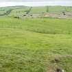
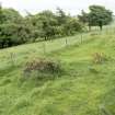
Crescentic scarps within the settlement at its W side, probably representing the remains of roundhouses |
30/5/2017 |
Item Level |
|
 |
On-line Digital Images |
DP 253265 |
Historic Environment Scotland |
The double bank of the settlement at the SW at its junction with the fort wall |
30/5/2017 |
Item Level |
|
 |
On-line Digital Images |
DP 253266 |
Historic Environment Scotland |
Crescentic scarps within the settlement at its W side, probably representing the remains of roundhouses |
30/5/2017 |
Item Level |
|
 |
On-line Digital Images |
DP 253267 |
Historic Environment Scotland |
Two later boundary walls at the point where they cross the fort wall, looking N |
30/5/2017 |
Item Level |
|
 |
On-line Digital Images |
DP 253268 |
Historic Environment Scotland |
Two later boundary walls at the point where they cross the fort wall, looking N |
30/5/2017 |
Item Level |
|
 |
On-line Digital Images |
DP 253269 |
Historic Environment Scotland |
The junction between the fort wall (left) and the settlement banks (right) at the E of the site |
30/5/2017 |
Item Level |
|
 |
On-line Digital Images |
DP 253270 |
Historic Environment Scotland |
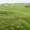
Indistinct scarps in the NE of the interior of the settlement |
30/5/2017 |
Item Level |
|
 |
On-line Digital Images |
DP 253271 |
Historic Environment Scotland |
The double bank of the settlement at the point it is cut by a later trackway, facing E |
30/5/2017 |
Item Level |
|
 |
On-line Digital Images |
DP 253272 |
Historic Environment Scotland |
Indistinct scarps in the NE of the interior of the settlement, and the later trackway (left) |
30/5/2017 |
Item Level |
|
 |
On-line Digital Images |
DP 253273 |
Historic Environment Scotland |
The ploughed down double bank and ditch of the settlement at the SSE |
30/5/2017 |
Item Level |
|
 |
On-line Digital Images |
DP 253274 |
Historic Environment Scotland |
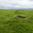
General view of the quarry immediately S of the settlement, looking S |
30/5/2017 |
Item Level |
|
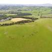 |
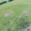
On-line Digital Images |
DP 259799 |
Historic Environment Scotland |
Oblique aerial view |
21/8/2017 |
Item Level |
|
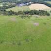 |
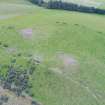
On-line Digital Images |
DP 259800 |
Historic Environment Scotland |
Oblique aerial view |
21/8/2017 |
Item Level |
|
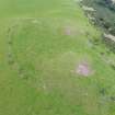 |
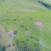
On-line Digital Images |
DP 259801 |
Historic Environment Scotland |
Oblique aerial view |
21/8/2017 |
Item Level |
|
 |
On-line Digital Images |
DP 259802 |
Historic Environment Scotland |
Oblique aerial view |
21/8/2017 |
Item Level |
|
 |
On-line Digital Images |
DP 259803 |
Historic Environment Scotland |
Oblique aerial view |
21/8/2017 |
Item Level |
|
 |
On-line Digital Images |
DP 259804 |
Historic Environment Scotland |
Oblique aerial view |
21/8/2017 |
Item Level |
|
 |
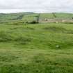
On-line Digital Images |
SC 1726059 |
RCAHMS Aerial Photography |
Black Hill, Lesmahagow, oblique aerial view, taken from the SSE, centred on the fort, settlement and cairn. |
20/2/1996 |
Item Level |
|


