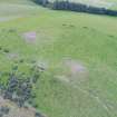
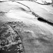
 |
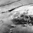
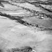
On-line Digital Images |
DP 259799 |
Historic Environment Scotland |
Oblique aerial view |
21/8/2017 |
Item Level |
|
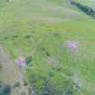
 |
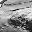
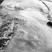
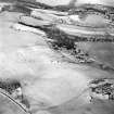
On-line Digital Images |
DP 259800 |
Historic Environment Scotland |
Oblique aerial view |
21/8/2017 |
Item Level |
|
 |
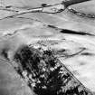
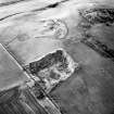
On-line Digital Images |
DP 259801 |
Historic Environment Scotland |
Oblique aerial view |
21/8/2017 |
Item Level |
|
 |
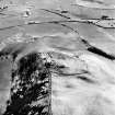
On-line Digital Images |
DP 259802 |
Historic Environment Scotland |
Oblique aerial view |
21/8/2017 |
Item Level |
|
 |
On-line Digital Images |
DP 259803 |
Historic Environment Scotland |
Oblique aerial view |
21/8/2017 |
Item Level |
|
 |
On-line Digital Images |
DP 259804 |
Historic Environment Scotland |
Oblique aerial view |
21/8/2017 |
Item Level |
|
 |
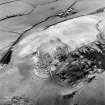
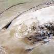
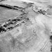
On-line Digital Images |
SC 1726059 |
RCAHMS Aerial Photography |
Black Hill, Lesmahagow, oblique aerial view, taken from the SSE, centred on the fort, settlement and cairn. |
20/2/1996 |
Item Level |
|
 |
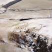
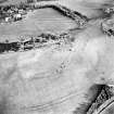
On-line Digital Images |
SC 1726060 |
RCAHMS Aerial Photography |
Black Hill, Lesmahagow, oblique aerial view, taken from the SE, centred on the fort, settlement and cairn. |
20/2/1996 |
Item Level |
|
 |
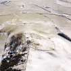
On-line Digital Images |
SC 1726061 |
RCAHMS Aerial Photography |
Black Hill, Lesmahagow, oblique aerial view, taken from the E, centred on the fort, settlement and cairn. |
20/2/1996 |
Item Level |
|
 |
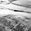
On-line Digital Images |
SC 1726062 |
RCAHMS Aerial Photography |
Black Hill, Lesmahagow, oblique aerial view, taken from the ENE, centred on the fort, settlement and cairn. |
20/2/1996 |
Item Level |
|
 |
On-line Digital Images |
SC 1726063 |
RCAHMS Aerial Photography |
Black Hill, Lesmahagow, oblique aerial view, taken from the NE, centred on the fort, settlement and cairn. |
20/2/1996 |
Item Level |
|
 |
On-line Digital Images |
SC 1726064 |
RCAHMS Aerial Photography |
Black Hill, Lesmahagow, oblique aerial view, taken from the N, centred on the fort, settlement and cairn. |
20/2/1996 |
Item Level |
|
 |
On-line Digital Images |
SC 1726069 |
RCAHMS Aerial Photography |
Black Hill, Lesmahagow, oblique aerial view, taken from the SE, centred on the fort, settlement and cairn. |
20/2/1996 |
Item Level |
|
 |
On-line Digital Images |
SC 1726070 |
RCAHMS Aerial Photography |
Black Hill, Lesmahagow, oblique aerial view, taken from the ENE, centred on the fort, settlement and cairn. |
20/2/1996 |
Item Level |
|
 |
On-line Digital Images |
SC 1726071 |
RCAHMS Aerial Photography |
Black Hill, Lesmahagow, oblique aerial view, taken from the N, centred on the fort, settlement and cairn. |
20/2/1996 |
Item Level |
|
 |
On-line Digital Images |
SC 1726081 |
RCAHMS Aerial Photography |
Oblique aerial view centred on the remains of the fort, settlement and cairn, taken from the NE. |
14/1/2000 |
Item Level |
|
 |
On-line Digital Images |
SC 1726082 |
RCAHMS Aerial Photography |
Oblique aerial view centred on the remains of the fort, settlement and cairn, taken from the N. |
14/1/2000 |
Item Level |
|
 |
On-line Digital Images |
SC 1726083 |
RCAHMS Aerial Photography |
Oblique aerial view centred on the remains of the fort, settlement and cairn, taken from the NNW. |
14/1/2000 |
Item Level |
|
 |
On-line Digital Images |
SC 1726084 |
RCAHMS Aerial Photography |
Oblique aerial view centred on the remains of the fort, settlement and cairn, taken from the NW. |
14/1/2000 |
Item Level |
|
 |
On-line Digital Images |
SC 1726085 |
RCAHMS Aerial Photography |
Oblique aerial view centred on the remains of the fort, settlement and cairn, taken from the WNW. |
14/1/2000 |
Item Level |
|
 |
On-line Digital Images |
SC 1726086 |
RCAHMS Aerial Photography |
Oblique aerial view centred on the remains of the fort, settlement and cairn, taken from the SW. |
14/1/2000 |
Item Level |
|
 |
On-line Digital Images |
SC 1726087 |
RCAHMS Aerial Photography |
Oblique aerial view centred on the remains of the fort, settlement and cairn, taken from the SSW. |
14/1/2000 |
Item Level |
|
 |
On-line Digital Images |
SC 1726090 |
RCAHMS Aerial Photography |
Oblique aerial view centred on the remains of the quarry with fort, settlement and cairn adjacent, taken from the ESE. |
14/1/2000 |
Item Level |
|
 |
On-line Digital Images |
SC 2431911 |
Records of the Ordnance Survey, Southampton, Hampshire, England |
Black Hill, Lesmahagow, NS84SW 15, Ordnance Survey index card, page number 1, Recto |
c. 1958 |
Item Level |
|


