 |
On-line Digital Images |
SC 1410153 |
Papers of Betty Willsher, historian, St Andrews, Scotland |
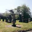
General view of burial ground, Gargunnock Parish Church.
|
1970 |
Item Level |
|
 |
On-line Digital Images |
SC 2221412 |
Papers of Betty Willsher, historian, St Andrews, Scotland |
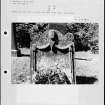
Photographs and research notes relating to graveyard monuments in Gargunnock Churchyard, Stirlingshire.
|
|
Item Level |
|
 |
On-line Digital Images |
SC 2221413 |
Papers of Betty Willsher, historian, St Andrews, Scotland |
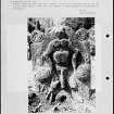
Photographs and research notes relating to graveyard monuments in Gargunnock Churchyard, Stirlingshire.
|
|
Item Level |
|
 |
On-line Digital Images |
SC 2221414 |
Papers of Betty Willsher, historian, St Andrews, Scotland |
Photographs and research notes relating to graveyard monuments in Gargunnock Churchyard, Stirlingshire.
|
|
Item Level |
|
 |
On-line Digital Images |
SC 2221415 |
Papers of Betty Willsher, historian, St Andrews, Scotland |
Photographs and research notes relating to graveyard monuments in Gargunnock Churchyard, Stirlingshire.
|
|
Item Level |
|
 |
On-line Digital Images |
SC 2431230 |
Records of the Ordnance Survey, Southampton, Hampshire, England |
Gargunnock, Parish Church And Burial-Ground, NS79SW 1, Ordnance Survey index card, Recto |
c. 1958 |
Item Level |
|
 |
On-line Digital Images |
SC 2431231 |
Records of the Ordnance Survey, Southampton, Hampshire, England |
Gargunnock, Parish Church And Burial-Ground, NS79SW 1, Ordnance Survey index card, Recto |
c. 1958 |
Item Level |
|
 |
On-line Digital Images |
SC 2495960 |
|
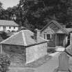
View of churchyard and New Manse from SW. |
1977 |
Item Level |
|
 |
On-line Digital Images |
SC 2495961 |
|
View of churchyard and former Manse from NW. |
1977 |
Item Level |
|


