 |
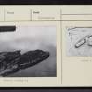
On-line Digital Images |
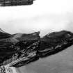
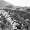
SC 337217 |
Records of the Ordnance Survey, Southampton, Hampshire, England |
View down onto Dun Canna fort from higher ground. |
10/7/1974 |
Item Level |
|
 |
On-line Digital Images |
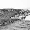
SC 735832 |
Papers of Helen Cameron Nisbet, geologist and archaeologist, Lasswade, Midlothian, Scotland |
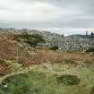
Copy of colour slide showing view of promontory fort, Dun Canna nr Ullapool, Highland - main (landward) rampart from seaward side
NMRS Survey of Private Collection
Digital Image only |
4/1973 |
Item Level |
|
 |
On-line Digital Images |
SC 735834 |
Papers of Helen Cameron Nisbet, geologist and archaeologist, Lasswade, Midlothian, Scotland |
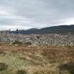
Copy of colour slide showing view of promontory fort, Dun Canna nr Ullapool, Highland - main (landward) defence from seaward side
NMRS Survey of Private Collection
Digital Image only |
4/1973 |
Item Level |
|
 |
On-line Digital Images |
SC 735835 |
Papers of Helen Cameron Nisbet, geologist and archaeologist, Lasswade, Midlothian, Scotland |
Copy of colour slide showing view of promontory fort, Dun Canna nr Ullapool, Highland - defence of main (landward) enclosure from seaward side
NMRS Survey of Private Collection
Digital Image only |
4/1973 |
Item Level |
|
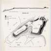 |
On-line Digital Images |
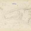
DP 148828 |
Records of the Royal Commission on the Ancient and Historical Monuments of Scotland (RCAHMS), Edinbu |
Publication drawing; plan and section of Dun Canna fort. |
c. 1947 |
Item Level |
|
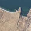 |
On-line Digital Images |
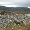
DP 156574 |
RCAHMS Aerial Photography Digital |
Oblique aerial view of Dun Canna fort and the adjacent fish trap, looking W. |
1/4/2013 |
Item Level |
|
 |
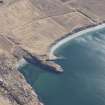
On-line Digital Images |
DP 156575 |
RCAHMS Aerial Photography Digital |
General oblique aerial view of Dun Canna fort and the adjacent fish trap, looking SW. |
1/4/2013 |
Item Level |
|
 |
On-line Digital Images |
DP 156576 |
RCAHMS Aerial Photography Digital |
Oblique aerial view of Dun Canna fort and the adjacent fish trap, looking SE. |
1/4/2013 |
Item Level |
|
 |
On-line Digital Images |
DP 156577 |
RCAHMS Aerial Photography Digital |
General oblique aerial view with Dun Canna fort and the adjacent fish trap in the foreground and Strath Canaird and the Rhidorroch Forest beyond, looking W. |
1/4/2013 |
Item Level |
|
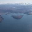 |
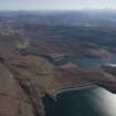
On-line Digital Images |
DP 156642 |
RCAHMS Aerial Photography Digital |
General oblique aerial view with Isle Martin and Loch Kanaird in the middle distance and Loch Broom and Ullapool beyond, looking SE. |
1/4/2013 |
Item Level |
|
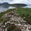 |
On-line Digital Images |
DP 238623 |
Papers of Dr George F Geddes, archaeologist, Edinburgh, Scotland |
General view of walling on the SE side of the lower fort. |
23/7/2016 |
Item Level |
|
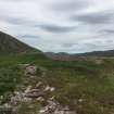 |
On-line Digital Images |
DP 238624 |
Papers of Dr George F Geddes, archaeologist, Edinburgh, Scotland |
General view along the SE side of the lower enclosure towards the upper enclosure. |
23/7/2016 |
Item Level |
|
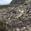 |
On-line Digital Images |
DP 238625 |
Papers of Dr George F Geddes, archaeologist, Edinburgh, Scotland |
Exposed outer wall face on the E wall of the E enclosure. |
23/7/2016 |
Item Level |
|
 |
On-line Digital Images |
SC 1924252 |
Dr Joanna Close-Brooks |
|
1984 |
Item Level |
|
 |
On-line Digital Images |
SC 1924253 |
Dr Joanna Close-Brooks |
|
1984 |
Item Level |
|
 |
On-line Digital Images |
DP 355282 |
Records of the Royal Commission on the Ancient and Historical Monuments of Scotland (RCAHMS), Edinbu |
Survey drawing; Dun Canna fort. |
9/10/1947 |
Item Level |
|
 |
On-line Digital Images |
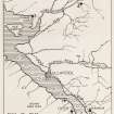
DP 355286 |
Records of the Royal Commission on the Ancient and Historical Monuments of Scotland (RCAHMS), Edinbu |
Publication drawing: Prehistoric Monuments near Ullapool: map showing sites. |
c. 1949 |
Item Level |
|
 |
On-line Digital Images |
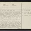
SC 2346077 |
Records of the Ordnance Survey, Southampton, Hampshire, England |
Dun Canna, NC10SW 1, Ordnance Survey index card, page number 1, Recto |
1958 |
Item Level |
|
 |
On-line Digital Images |
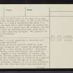
SC 2346078 |
Records of the Ordnance Survey, Southampton, Hampshire, England |
Dun Canna, NC10SW 1, Ordnance Survey index card, page number 2, Verso |
1958 |
Item Level |
|
 |
On-line Digital Images |
SC 2346079 |
Records of the Ordnance Survey, Southampton, Hampshire, England |
Dun Canna, NC10SW 1, Ordnance Survey index card, page number 3, Recto |
1958 |
Item Level |
|
 |
On-line Digital Images |
SC 2346080 |
Records of the Ordnance Survey, Southampton, Hampshire, England |
Dun Canna, NC10SW 1, Ordnance Survey index card, Recto |
1958 |
Item Level |
|
 |
On-line Digital Images |
SC 2346081 |
Records of the Ordnance Survey, Southampton, Hampshire, England |
Dun Canna, NC10SW 1, Ordnance Survey index card, Recto |
1958 |
Item Level |
|
 |
On-line Digital Images |
SC 2346082 |
Records of the Ordnance Survey, Southampton, Hampshire, England |
Dun Canna, NC10SW 1, Ordnance Survey index card, Recto |
1958 |
Item Level |
|
 |
On-line Digital Images |
SC 2346083 |
Records of the Ordnance Survey, Southampton, Hampshire, England |
Dun Canna, NC10SW 1, Ordnance Survey index card, Recto |
1958 |
Item Level |
|


