 |
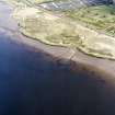
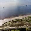
On-line Digital Images |
SC 1724744 |
RCAHMS Aerial Photography |
Oblique aerial view centred on the remains of the Dumbuck crannog, taken from the SE. |
10/5/2005 |
Item Level |
|
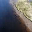 |
On-line Digital Images |
SC 1724745 |
RCAHMS Aerial Photography |
Oblique aerial view centred on the remains of the Dumbuck crannog, taken from the ESE. |
10/5/2005 |
Item Level |
|
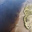 |
On-line Digital Images |
SC 1724746 |
RCAHMS Aerial Photography |
Oblique aerial view centred on the remains of the Dumbuck crannog, taken from the E. |
10/5/2005 |
Item Level |
|
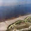 |
On-line Digital Images |
SC 1724747 |
RCAHMS Aerial Photography |
Oblique aerial view centred on the remains of the Dumbuck crannog, taken from the NE. |
10/5/2005 |
Item Level |
|
 |
On-line Digital Images |
SC 1724748 |
RCAHMS Aerial Photography |
Oblique aerial view centred on the remains of the Dumbuck crannog, taken from the NNE. |
10/5/2005 |
Item Level |
|
 |
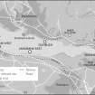
On-line Digital Images |
SC 2077106 |
Historic Environment Scotland |
Plan of Dumbuck Crannog |
12/2015 |
Item Level |
|
 |
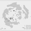
On-line Digital Images |
SC 2077108 |
Historic Environment Scotland |
Map of Clyde Crannogs; Dumbuck, Langbank East, Langbank West, Erskine |
12/2015 |
Item Level |
|
 |
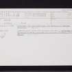
On-line Digital Images |
SC 2426107 |
Records of the Ordnance Survey, Southampton, Hampshire, England |
Dumbuck, NS47SW 8, Ordnance Survey index card, Recto |
1958 |
Item Level |
|
 |
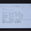
On-line Digital Images |
SC 2426108 |
Records of the Ordnance Survey, Southampton, Hampshire, England |
Dumbuck, NS47SW 8, Ordnance Survey index card, Recto |
1958 |
Item Level |
|
 |
On-line Digital Images |
SC 2426109 |
Records of the Ordnance Survey, Southampton, Hampshire, England |
Dumbuck, NS47SW 8, Ordnance Survey index card, Recto |
1958 |
Item Level |
|


