 |
On-line Digital Images |
SC 1007567 |
RCAHMS Aerial Photography |
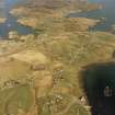
General oblique aerial view centred on the township with the burial-ground, church and township adjacent, taken from the W. |
23/4/2005 |
Item Level |
|
 |
On-line Digital Images |
SC 1690929 |
RCAHMS Aerial Photography |
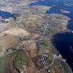
General oblique aerial view centred on the township with the burial-ground, church and cemeteries and township adjacent, taken from the WNW. |
23/4/2005 |
Item Level |
|
 |
On-line Digital Images |
SC 1692290 |
RCAHMS Aerial Photography |
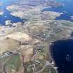
General oblique aerial view centred on the township with the burial-ground, church and township adjacent, taken from the W. |
23/4/2005 |
Item Level |
|
 |
On-line Digital Images |
SC 2345451 |
Records of the Ordnance Survey, Southampton, Hampshire, England |
Lewis, Garyvard, NB32SE 7, Ordnance Survey index card, Recto |
c. 1958 |
Item Level |
|


