 |
On-line Digital Images |
SC 1690867 |
RCAHMS Aerial Photography |
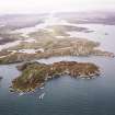
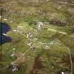
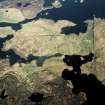
General oblique aerial view looking across the township towards Loch Eireasort, taken from the ESE. |
29/9/2004 |
Item Level |
|
 |
On-line Digital Images |
SC 1690868 |
RCAHMS Aerial Photography |
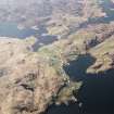
General oblique aerial view looking across the township towards Loch Eireasort, taken from the E. |
29/9/2004 |
Item Level |
|
 |
On-line Digital Images |
SC 1690907 |
RCAHMS Aerial Photography |
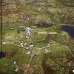
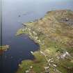
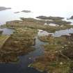
General oblique aerial view centred on the village, taken from the NNE. |
23/4/2005 |
Item Level |
|
 |
On-line Digital Images |
SC 1692228 |
RCAHMS Aerial Photography |
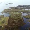
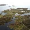
Oblique aerial view centred on the township, taken from the WNW. |
24/9/2004 |
Item Level |
|
 |
On-line Digital Images |
SC 1692229 |
RCAHMS Aerial Photography |
Oblique aerial view centred on the township, taken from the W. |
24/9/2004 |
Item Level |
|
 |
On-line Digital Images |
SC 1692230 |
RCAHMS Aerial Photography |
Oblique aerial view centred on the township, taken from the SW. |
24/9/2004 |
Item Level |
|
 |
On-line Digital Images |
SC 1692231 |
RCAHMS Aerial Photography |
Oblique aerial view centred on the township, taken from the SW. |
24/9/2004 |
Item Level |
|
 |
On-line Digital Images |
SC 1692232 |
RCAHMS Aerial Photography |
Distant oblique aerial view centred on the township, taken from the WSW. |
24/9/2004 |
Item Level |
|
 |
On-line Digital Images |
SC 1692264 |
RCAHMS Aerial Photography |
General oblique aerial view looking across the township towards Loch Eireasort, taken from the E. |
29/9/2004 |
Item Level |
|
 |
On-line Digital Images |
SC 1692272 |
RCAHMS Aerial Photography |
General oblique aerial view centred on the village, taken from the SSE. |
23/4/2005 |
Item Level |
|
 |
On-line Digital Images |
SC 1692424 |
RCAHMS Aerial Photography |
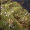
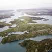
Distant oblique aerial view looking towards the remains of the galleried dun and township adjacent, taken from the WSW. |
24/9/2004 |
Item Level |
|
 |
On-line Digital Images |
SC 1692425 |
RCAHMS Aerial Photography |
Distant oblique aerial view looking towards the remains of the galleried dun and township adjacent, taken from the SW. |
24/9/2004 |
Item Level |
|
|
Photographs and Off-line Digital Images |
SC 1927201 |
Cambridge University Collection for Aerial Photography |
Aerial view from NW |
1965 |
Item Level |
|
 |
On-line Digital Images |
SC 2345447 |
Records of the Ordnance Survey, Southampton, Hampshire, England |
Lewis, Cromor, NB32SE 3, Ordnance Survey index card, Recto |
c. 1958 |
Item Level |
|


