 |
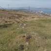
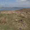
On-line Digital Images |
DP 209506 |
RCAHMS Field Survey Digital Photography |
Lurg Moor. General view of hut circle, facing NW. |
8/4/2015 |
Item Level |
|
 |
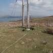
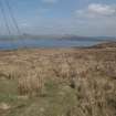
On-line Digital Images |
DP 209507 |
RCAHMS Field Survey Digital Photography |
Lurg Moor. View of west of hut circle, and area of wall disturbed by stanchion. |
8/4/2015 |
Item Level |
|
 |
On-line Digital Images |
DP 209508 |
RCAHMS Field Survey Digital Photography |
Lurg Moor. View of north of hut circle, and area of wall disturbed by stanchion. |
8/4/2015 |
Item Level |
|
 |
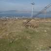
On-line Digital Images |
DP 209509 |
RCAHMS Field Survey Digital Photography |
Lurg Moor. View of east of hut circle, and disturbance caused by the erection of electricty poles. |
8/4/2015 |
Item Level |
|
 |
On-line Digital Images |
DP 209510 |
RCAHMS Field Survey Digital Photography |
Lurg Moor. View of bank leading off to NE at entrance to hut circle. |
8/4/2015 |
Item Level |
|
 |
On-line Digital Images |
DP 209511 |
RCAHMS Field Survey Digital Photography |
Lurg Moor. View of bank leading off to NE at entrance to hut circle. |
8/4/2015 |
Item Level |
|
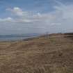 |
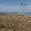
On-line Digital Images |
DP 209516 |
RCAHMS Field Survey Digital Photography |
Lurg Moor. General view of location of hut circle, facing E. |
8/4/2015 |
Item Level |
|
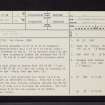 |
On-line Digital Images |
SC 2422413 |
Records of the Ordnance Survey, Southampton, Hampshire, England |
Lurg Moor, NS27SE 7, Ordnance Survey index card, page number 1, Recto |
1958 |
Item Level |
|


