 |
On-line Digital Images |
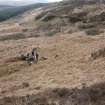
DP 066537 |
RCAHMS Field Survey Digital Photography |
General view, taken from the NW, |
31/3/2009 |
Item Level |
|
 |
On-line Digital Images |
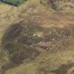
DP 067116 |
RCAHMS Aerial Photography Digital |
Oblique aerial view centred on Muclich Hill, taken from the NW. |
6/10/2009 |
Item Level |
|
 |
On-line Digital Images |
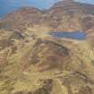
DP 067119 |
RCAHMS Aerial Photography Digital |
Oblique aerial view looking towards the Lagganbeg burn, taken from the S. |
6/10/2009 |
Item Level |
|
 |
On-line Digital Images |
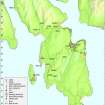
DP 097423 |
Records of the Royal Commission on the Ancient and Historical Monuments of Scotland (RCAHMS), Edinbu |
Map - Distribution of Early Historic and Medieval sites and artefacts. |
8/2010 |
Item Level |
|
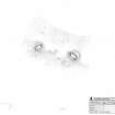 |
On-line Digital Images |
SC 1231964 |
Records of the Royal Commission on the Ancient and Historical Monuments of Scotland (RCAHMS), Edinbu |
RCAHMS survey drawing; Plan of the huts at Muclich Hill, undertaken with volunteers. |
14/10/2010 |
Item Level |
|
 |
On-line Digital Images |
SC 2420677 |
Records of the Ordnance Survey, Southampton, Hampshire, England |
Bute, Muclich Hill, NS07SW 24, Ordnance Survey index card, Recto |
1958 |
Item Level |
|
 |
On-line Digital Images |
SC 2420678 |
Records of the Ordnance Survey, Southampton, Hampshire, England |
Bute, Muclich Hill, NS07SW 24, Ordnance Survey index card, Recto |
1958 |
Item Level |
|
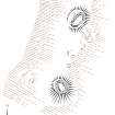 |
On-line Digital Images |
SC 2605723 |
Records of the Royal Commission on the Ancient and Historical Monuments of Scotland (RCAHMS), Edinbu |
Muclich Hill shieling huts, plan. Unpublished illustration. |
2020 |
Item Level |
|


