 |
On-line Digital Images |
DP 066200 |
RCAHMS Aerial Photography Digital |
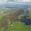
General oblique aerial view looking towards Loch Dhu and Barone Hill in the distance from Scalpsie Bay, taken from the SSW. Loch Quien is at the bottom right, with Loch Fad beyond it. |
9/9/2009 |
Item Level |
|
 |
On-line Digital Images |
SC 1163938 |
|
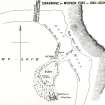
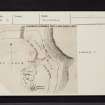
Plan (Mackinlay 1862). |
c. 1826 |
Item Level |
|
 |
On-line Digital Images |
DP 097422 |
Records of the Royal Commission on the Ancient and Historical Monuments of Scotland (RCAHMS), Edinbu |
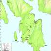
Map - Distribution of sites and artefacts of the Late Bronze Age and Iron Age. |
8/2010 |
Item Level |
|
 |
On-line Digital Images |
SC 2420470 |
Records of the Ordnance Survey, Southampton, Hampshire, England |
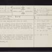
Bute, Loch Dhu, NS06SE 16, Ordnance Survey index card, page number 1, Recto |
c. 1958 |
Item Level |
|
 |
On-line Digital Images |
SC 2420471 |
Records of the Ordnance Survey, Southampton, Hampshire, England |
Bute, Loch Dhu, NS06SE 16, Ordnance Survey index card, Recto |
c. 1958 |
Item Level |
|


