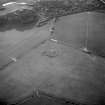
 |
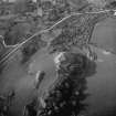
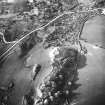
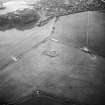
On-line Digital Images |
SC 1146498 |
RCAHMS Aerial Photography |
Oblique aerial view. |
1993 |
Item Level |
|
 |
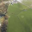
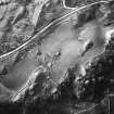
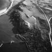
On-line Digital Images |
DP 062656 |
RCAHMS Aerial Photography Digital |
General oblique aerial view centred on the remains of the cairn with the remains of the dun adjacent, taken from the SW. |
6/2/2009 |
Item Level |
|
 |
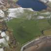
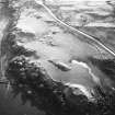
On-line Digital Images |
DP 062657 |
RCAHMS Aerial Photography Digital |
General oblique aerial view looking towards Kilmory Hill, taken from the SE. |
6/2/2009 |
Item Level |
|
 |
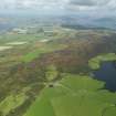
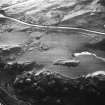
On-line Digital Images |
DP 062682 |
RCAHMS Aerial Photography Digital |
Oblique aerial view centred on the remains of the cairn with the remains of the dun adjacent, taken from the S. |
6/2/2009 |
Item Level |
|
 |
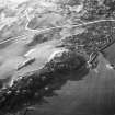
On-line Digital Images |
SC 1152236 |
RCAHMS Aerial Photography |
Oblique aerial photograph taken from the east. |
1993 |
Item Level |
|
 |
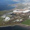
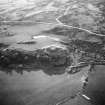
On-line Digital Images |
DP 066202 |
RCAHMS Aerial Photography Digital |
General oblique aerial view looking towards North Bute from Scalpsie Bay, taken from the S. |
9/9/2009 |
Item Level |
|
 |
On-line Digital Images |
SC 1167958 |
Records of the Royal Commission on the Ancient and Historical Monuments of Scotland (RCAHMS), Edinbu |
RCAHMS, Emergency Survey, 27 May 1943 |
27/5/1943 |
Item Level |
|
 |
On-line Digital Images |
SC 1167959 |
Records of the Ordnance Survey, Southampton, Hampshire, England |
Plan, copied from OS '495' card |
4/11/1976 |
Item Level |
|
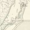 |
On-line Digital Images |
SC 1167960 |
|
Extract of the OS 1st edition map, 1869. |
1869 |
Item Level |
|
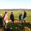 |
On-line Digital Images |
DP 084694 |
Records of the Royal Commission on the Ancient and Historical Monuments of Scotland (RCAHMS), Edinbu |
View of RCAHMS staff and members of the public, taken from the SW. From left to right: unknown; Isabell Mcarthur, Angus Hannah, Donald Kinnear, Alex Hale (RCAHMS), unknown. |
8/12/2008 |
Item Level |
|
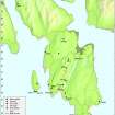 |
On-line Digital Images |
DP 097422 |
Records of the Royal Commission on the Ancient and Historical Monuments of Scotland (RCAHMS), Edinbu |
Map - Distribution of sites and artefacts of the Late Bronze Age and Iron Age. |
8/2010 |
Item Level |
|
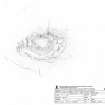 |
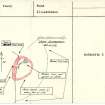
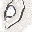
On-line Digital Images |
SC 1231932 |
Records of the Royal Commission on the Ancient and Historical Monuments of Scotland (RCAHMS), Edinbu |
RCAHMS survey drawing; Plan of Dun Scalpsie. |
16/3/2010 |
Item Level |
|
 |
On-line Digital Images |
DP 097436 |
Records of the Royal Commission on the Ancient and Historical Monuments of Scotland (RCAHMS), Edinbu |
RCAHMS publication drawing; Plan of Dun Scalpsie |
8/2010 |
Item Level |
|
 |
On-line Digital Images |
SC 1233420 |
Copies of records from Bute Museum, Rothesay, Bute, Argyll and Bute, Scotland |
Inner face of rampart. An image from the Buteshire Natural History Society archaeology photograph album, held at Bute Museum.
|
7/1959 |
Item Level |
|
 |
On-line Digital Images |
SC 1723961 |
RCAHMS Aerial Photography |
An oblique aerial view, centred on the remains of the building, taken from the S. |
1993 |
Item Level |
|
 |
On-line Digital Images |
SC 1723963 |
RCAHMS Aerial Photography |
Oblique aerial view. |
1993 |
Item Level |
|
 |
On-line Digital Images |
SC 1723964 |
RCAHMS Aerial Photography |
Oblique aerial view. |
1993 |
Item Level |
|
 |
On-line Digital Images |
SC 1723965 |
RCAHMS Aerial Photography |
Oblique aerial view. |
1993 |
Item Level |
|
 |
On-line Digital Images |
SC 1723966 |
RCAHMS Aerial Photography |
Oblique aerial view. |
1993 |
Item Level |
|
 |
On-line Digital Images |
SC 1723967 |
RCAHMS Aerial Photography |
Oblique aerial view. |
1993 |
Item Level |
|
 |
On-line Digital Images |
SC 1723968 |
RCAHMS Aerial Photography |
Oblique aerial view. |
1993 |
Item Level |
|
 |
On-line Digital Images |
SC 1723970 |
RCAHMS Aerial Photography |
Oblique aerial photograph taken from the east. |
1993 |
Item Level |
|
 |
On-line Digital Images |
SC 2420100 |
Records of the Ordnance Survey, Southampton, Hampshire, England |
Bute, Dun Scalpsie, NS05NE 4, Ordnance Survey index card, page number 3, Recto |
c. 1958 |
Item Level |
|
 |
On-line Digital Images |
SC 2420101 |
Records of the Ordnance Survey, Southampton, Hampshire, England |
Bute, Dun Scalpsie, NS05NE 4, Ordnance Survey index card, page number 1, Recto |
c. 1958 |
Item Level |
|


