 |
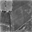
On-line Digital Images |
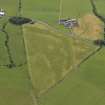
DP 062969 |
RCAHMS Aerial Photography Digital |
Oblique aerial view centred on the cropmarks of the plantation bank and field boundaries, taken from the NE. |
2/8/2009 |
Item Level |
|
 |
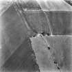
On-line Digital Images |
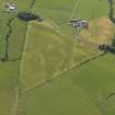
DP 062970 |
RCAHMS Aerial Photography Digital |
Oblique aerial view centred on the cropmarks of the plantation bank and field boundaries, taken from the N. |
2/8/2009 |
Item Level |
|
 |
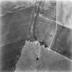
On-line Digital Images |
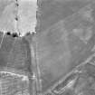
SC 1203417 |
RCAHMS Aerial Photography |
Oblique aerial view centred on the cropmark enclosure, taken from the SSW. |
7/7/1977 |
Item Level |
|
 |
On-line Digital Images |
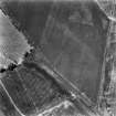
SC 1723911 |
RCAHMS Aerial Photography |
Oblique aerial view centred on the cropmark enclosure, taken from the NE. |
7/7/1977 |
Item Level |
|
 |
On-line Digital Images |
SC 1723912 |
RCAHMS Aerial Photography |
Oblique aerial view centred on the cropmark enclosure, taken from the SSW. |
7/7/1977 |
Item Level |
|
 |
On-line Digital Images |
SC 1723913 |
RCAHMS Aerial Photography |
Oblique aerial view centred on the cropmark enclosure, taken from the SW. |
7/7/1977 |
Item Level |
|
 |
On-line Digital Images |
SC 1723914 |
RCAHMS Aerial Photography |
Oblique aerial view centred on the cropmark, taken from the S. |
7/7/1977 |
Item Level |
|
 |
On-line Digital Images |
SC 2420134 |
Records of the Ordnance Survey, Southampton, Hampshire, England |
Bute, Langalbuinoch, NS05NE 21, Ordnance Survey index card, Recto |
c. 1958 |
Item Level |
|
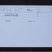 |
On-line Digital Images |
SC 2420135 |
Records of the Ordnance Survey, Southampton, Hampshire, England |
Bute, Langalbuinoch, NS05NE 21, Ordnance Survey index card, Recto |
c. 1958 |
Item Level |
|


