 |
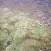
On-line Digital Images |
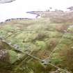
SC 1691821 |
RCAHMS Aerial Photography |
Oblique aerial view centred on the township, taken from the WSW. |
28/9/2004 |
Item Level |
|
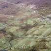 |
On-line Digital Images |
SC 1691822 |
RCAHMS Aerial Photography |
Oblique aerial view centred on the township, taken from the SW. |
28/9/2004 |
Item Level |
|
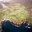 |
On-line Digital Images |
SC 1691823 |
RCAHMS Aerial Photography |
Oblique aerial view centred on the township, taken from the SW. |
28/9/2004 |
Item Level |
|
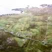 |
On-line Digital Images |
SC 1691824 |
RCAHMS Aerial Photography |
Oblique aerial view centred on the township, taken from the ENE. |
28/9/2004 |
Item Level |
|
 |
On-line Digital Images |
SC 1691825 |
RCAHMS Aerial Photography |
Oblique aerial view centred on the township, taken from the NE. |
28/9/2004 |
Item Level |
|
 |
On-line Digital Images |
SC 2344927 |
Records of the Ordnance Survey, Southampton, Hampshire, England |
Lewis, Brenish, NA92NE 2, Ordnance Survey index card, Recto |
c. 1958 |
Item Level |
|


