 |
On-line Digital Images |
DP 095512 |
RCAHMS Aerial Photography Digital |
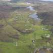
General oblique aerial view of Lower Kilchattan and Upper Kilchattan looking towards Loch Fada, taken from the SW. |
1/9/2010 |
Item Level |
|
 |
On-line Digital Images |
DP 095513 |
RCAHMS Aerial Photography Digital |
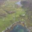
General oblique aerial view of Lower Kilchattan and Upper Kilchattan looking towards Loch Fada with the harbour in the foreground, taken from the SW. |
1/9/2010 |
Item Level |
|
 |
On-line Digital Images |
DP 172383 |
Records of the Royal Commission on the Ancient and Historical Monuments of Scotland (RCAHMS), Edinbu |
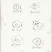
Survey plans of 6 chapels;
Cill Mhoire; Cill Eileagain, Mulreesh; Cill Choman; Kilslevan, Cill Slebhan; Duisker; Cill Eathain. |
c. 1980 |
Item Level |
|
 |
On-line Digital Images |
DP 172385 |
Records of the Royal Commission on the Ancient and Historical Monuments of Scotland (RCAHMS), Edinbu |
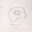
Survey drawing; Colonsay, Upper Kilchattan, Cill Mhoire.
|
11/5/1977 |
Item Level |
|
 |
On-line Digital Images |
SC 2414517 |
Records of the Ordnance Survey, Southampton, Hampshire, England |
Colonsay, Upper Kilchattan, Cill Mhoire, NR39NE 6, Ordnance Survey index card, Recto |
c. 1958 |
Item Level |
|
 |
On-line Digital Images |
SC 2414518 |
Records of the Ordnance Survey, Southampton, Hampshire, England |
Colonsay, Upper Kilchattan, Cill Mhoire, NR39NE 6, Ordnance Survey index card, page number 1, Recto |
c. 1958 |
Item Level |
|
 |
On-line Digital Images |
SC 2414519 |
Records of the Ordnance Survey, Southampton, Hampshire, England |
Colonsay, Upper Kilchattan, Cill Mhoire, NR39NE 6, Ordnance Survey index card, page number 2, Verso |
c. 1958 |
Item Level |
|


