 |
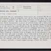
On-line Digital Images |
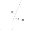
SC 342987 |
Records of the Royal Commission on the Ancient and Historical Monuments of Scotland (RCAHMS), Edinbu |
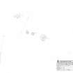
NAS Antiquity model drawing. Photographic copy of drawing. |
|
Item Level |
|
 |
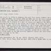
On-line Digital Images |
SC 682173 |
Records of the Society of Antiquaries of Scotland, Edinburgh, Scotland |
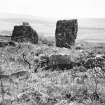
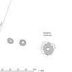
View showing three uprights of stone circle and kerb of ring-cairn.
Print card captioned: 'Northern circle - view from N.E., showing inner hollow, standing stones on outer part of ring on S.W. and outer standing stones beyond.'
Perspective opposite to that of KC 378. |
|
Item Level |
|
 |
On-line Digital Images |
SC 682190 |
Records of the Society of Antiquaries of Scotland, Edinburgh, Scotland |
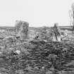
View of uprights of circle and outer kerb of ring cairn from the west.
Print card captioned: 'Northern circle - standing stone of outer circle & back of stone setting with standing stone - west side.'
Perspective opposite to that of KC 376. |
|
Item Level |
|
 |
On-line Digital Images |
SC 1303191 |
Records of the Royal Commission on the Ancient and Historical Monuments of Scotland (RCAHMS), Edinbu |
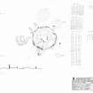
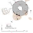
RCAHMS survey drawing: Plan, elevation and sections of Campstone Hill, Raedykes stone circle |
13/4/2005 |
Item Level |
|
 |
On-line Digital Images |
SC 1472649 |
|
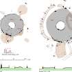
RCAHMS survey drawing: Campstone Hill, Raedykes. Plan of ring-cairns NO89SW 6, 7, 8 & 9. |
15/4/2005 |
Item Level |
|
 |
On-line Digital Images |
SC 1556034 |
Historic Environment Scotland |
HES Survey and Recording Illustration: Plan of Campstone Hill, Raedykes. |
1/2017 |
Item Level |
|
 |
On-line Digital Images |
SC 1916739 |
Records of the Royal Commission on the Ancient and Historical Monuments of Scotland (RCAHMS), Edinbu |
RCAHMS illustration: Plan of Raedykes NW. |
19/8/2010 |
Item Level |
|
 |
On-line Digital Images |
SC 1918320 |
Records of the Royal Commission on the Ancient and Historical Monuments of Scotland (RCAHMS), Edinbu |
RCAHMS publication drawing: Campstone Hill, Fetteress: Raedykes north-west and Raedykes south-east. |
19/8/2010 |
Item Level |
|
 |
On-line Digital Images |
SC 2413146 |
Records of the Ordnance Survey, Southampton, Hampshire, England |
Campstone Hill, Raedykes, NO89SW 6, Ordnance Survey index card, page number 1, Recto |
1958 |
Item Level |
|
 |
On-line Digital Images |
SC 2413147 |
Records of the Ordnance Survey, Southampton, Hampshire, England |
Campstone Hill, Raedykes, NO89SW 6, Ordnance Survey index card, page number 2, Recto |
1958 |
Item Level |
|
 |
On-line Digital Images |
SC 2413148 |
Records of the Ordnance Survey, Southampton, Hampshire, England |
Campstone Hill, Raedykes, NO89SW 6, Ordnance Survey index card, Recto |
1958 |
Item Level |
|
 |
On-line Digital Images |
SC 2413149 |
Records of the Ordnance Survey, Southampton, Hampshire, England |
Campstone Hill, Raedykes, NO89SW 6, Ordnance Survey index card, Recto |
1958 |
Item Level |
|


