 |
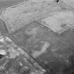
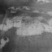
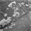
On-line Digital Images |
SC 992729 |
Records of Aberdeen Aerial Surveys, Aberdeen, Scotland |
Oblique aerial view centred on the cropmarks of the unenclosed settlement, ring ditch, soutterains and pits at Burnhead of Mondobbo, looking to the NNE. |
6/7/1983 |
Item Level |
|
 |
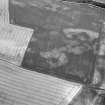
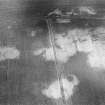
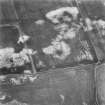
On-line Digital Images |
SC 992737 |
Records of Aberdeen Aerial Surveys, Aberdeen, Scotland |
Oblique aerial view centred on the cropmarks of the unenclosed settlement, ring ditch, souterrains and pits at Burnhead of Monboddo, looking to the SSE. |
6/7/1983 |
Item Level |
|
 |
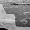
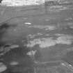
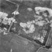
On-line Digital Images |
SC 992738 |
Records of Aberdeen Aerial Surveys, Aberdeen, Scotland |
Oblique aerial view centred on the cropmarks of the unenclosed settlement, ring ditch, souterrains and pits at Burnhead of Monboddo, looking to the NW. |
6/7/1983 |
Item Level |
|
 |
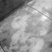
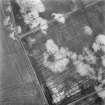
On-line Digital Images |
SC 1003581 |
Records of Aberdeen Aerial Surveys, Aberdeen, Scotland |
Oblique aerial view centred on the cropmarks of the unenclosed settlement, ring ditch, soutterains and pits at Burnhead of Mondobbo, looking to the SSE. |
20/7/1983 |
Item Level |
|
 |
On-line Digital Images |
SC 1003582 |
Records of Aberdeen Aerial Surveys, Aberdeen, Scotland |
Oblique aerial view centred on the cropmarks of the unenclosed settlement, ring ditch, soutterains and pits at Burnhead of Mondobbo, looking to the SSE. |
20/7/1983 |
Item Level |
|
 |
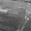
On-line Digital Images |
SC 1013317 |
Records of Aberdeen Aerial Surveys, Aberdeen, Scotland |
Oblique aerial view centred on the cropmarks of the unenclosed settlement, ring ditch, souterrains and pits at Burnhead of Monboddo, looking to the ENE. |
5/7/1982 |
Item Level |
|
 |
On-line Digital Images |
SC 1013318 |
Records of Aberdeen Aerial Surveys, Aberdeen, Scotland |
Oblique aerial view centred on the cropmarks of the unenclosed settlement, ring ditch, souterrains and pits at Burnhead of Monboddo, looking to the NNW. |
5/7/1982 |
Item Level |
|
 |
On-line Digital Images |
SC 1013319 |
Records of Aberdeen Aerial Surveys, Aberdeen, Scotland |
Oblique aerial view centred on the cropmarks of the unenclosed settlement, ring ditch, souterrains and pits at Burnhead of Monboddo, looking to the NNW. |
5/7/1982 |
Item Level |
|
 |
On-line Digital Images |
SC 1013320 |
Records of Aberdeen Aerial Surveys, Aberdeen, Scotland |
Oblique aerial view centred on the cropmarks of the unenclosed settlement, ring ditch, souterrains and pits at Burnhead of Monboddo, looking to the NNW. |
5/7/1982 |
Item Level |
|
 |
On-line Digital Images |
SC 1013813 |
Records of Aberdeen Aerial Surveys, Aberdeen, Scotland |
Oblique aerial view centred on the cropmarks of the unenclosed settlement, ring ditch, souterrains and pits at Burnhead of Monboddo, looking to the NE. |
24/7/1982 |
Item Level |
|
 |
On-line Digital Images |
SC 1722944 |
RCAHMS Aerial Photography |
Oblique aerial view. |
1982 |
Item Level |
|
 |
On-line Digital Images |
SC 1722945 |
RCAHMS Aerial Photography |
Oblique aerial view. |
1982 |
Item Level |
|
 |
On-line Digital Images |
SC 1722946 |
RCAHMS Aerial Photography |
Oblique aerial view. |
1982 |
Item Level |
|
 |
On-line Digital Images |
SC 1722947 |
RCAHMS Aerial Photography |
Oblique aerial view. |
1982 |
Item Level |
|
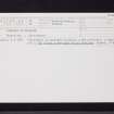 |
On-line Digital Images |
SC 2411913 |
Records of the Ordnance Survey, Southampton, Hampshire, England |
Burnhead Of Monboddo, NO77NW 44, Ordnance Survey index card, Recto |
1958 |
Item Level |
|
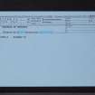 |
On-line Digital Images |
SC 2411914 |
Records of the Ordnance Survey, Southampton, Hampshire, England |
Burnhead Of Monboddo, NO77NW 44, Ordnance Survey index card, Recto |
1958 |
Item Level |
|


