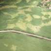
 |
On-line Digital Images |
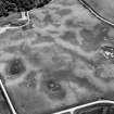
SC 1013316 |
Records of Aberdeen Aerial Surveys, Aberdeen, Scotland |
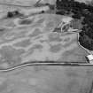
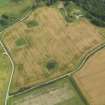
Oblique aerial view centred on the cropmarks of the unenclosed settlement, enclosure and pits at Monboddo House, looking to the ESE. |
5/7/1982 |
Item Level |
|
 |
On-line Digital Images |
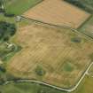
SC 1013807 |
Records of Aberdeen Aerial Surveys, Aberdeen, Scotland |
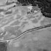
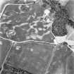
Oblique aerial view centred on the cropmarks of the unenclosed settlement, circular enclosure, ring ditch and pits at Monboddo, looking to the NE. |
24/7/1982 |
Item Level |
|
 |
On-line Digital Images |
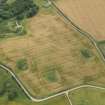
SC 1013809 |
Records of Aberdeen Aerial Surveys, Aberdeen, Scotland |
Oblique aerial view centred on the cropmarks of the unenclosed settlement, circular enclosure, ring ditch and pits at Monboddo, looking to the NE. |
24/7/1982 |
Item Level |
|
 |
On-line Digital Images |
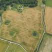
SC 1013811 |
Records of Aberdeen Aerial Surveys, Aberdeen, Scotland |
Oblique aerial view centred on the cropmarks of the unenclosed settlement, circular enclosure, ring ditch and pits at Monboddo, looking to the SE. |
24/7/1982 |
Item Level |
|
 |
On-line Digital Images |
SC 1013812 |
Records of Aberdeen Aerial Surveys, Aberdeen, Scotland |
Oblique aerial view centred on the cropmarks of the unenclosed settlement, circular enclosure, ring ditch and pits at Monboddo, looking to the S. |
24/7/1982 |
Item Level |
|
 |
On-line Digital Images |
DP 052811 |
RCAHMS Aerial Photography Digital |
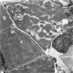
Oblique aerial view of the cropmarks of the enclosure and timber hall at Monboddo, taken from the NE. |
4/8/2008 |
Item Level |
|
 |
On-line Digital Images |
DP 052812 |
RCAHMS Aerial Photography Digital |
Oblique aerial view of the cropmarks of the enclosure and timber hall at Monboddo, taken from the N. |
4/8/2008 |
Item Level |
|
 |
On-line Digital Images |
DP 052813 |
RCAHMS Aerial Photography Digital |
Oblique aerial view of the cropmarks of the enclosure and timber hall at Monboddo, taken from the NNW. |
4/8/2008 |
Item Level |
|
 |
On-line Digital Images |
DP 052814 |
RCAHMS Aerial Photography Digital |
Oblique aerial view of the cropmarks of the enclosure and timber hall at Monboddo, taken from the WNW. |
4/8/2008 |
Item Level |
|
|
Photographs and Off-line Digital Images |
AT 003309 |
RCAHMS Aerial Transcription |
Imagery and mapping Files for Aerial Photo Transcription |
10/4/2012 |
Item Level |
|
|
Photographs and Off-line Digital Images |
SC 1722809 |
Records of Aberdeenshire Archaeology Service, Aberdeen, Scotland
|
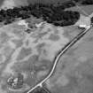
Oblique aerial view of Monboddo House centred on cropmarks of a possible enclosed timber hall, ring ditch, pits and enclosure, taken from the SE. |
20/7/2000 |
Item Level |
|
|
Photographs and Off-line Digital Images |
SC 1722810 |
Records of Aberdeenshire Archaeology Service, Aberdeen, Scotland
|
Oblique aerial view of Monboddo House centred on cropmarks of a possible enclosed timber hall, ring-ditch, pits and enclosure, taken from the E. |
20/7/2000 |
Item Level |
|
|
Photographs and Off-line Digital Images |
SC 1722817 |
RCAHMS Aerial Photography |
Oblique aerial view. |
1982 |
Item Level |
|
|
Photographs and Off-line Digital Images |
SC 1722818 |
RCAHMS Aerial Photography |
Oblique aerial view. |
1982 |
Item Level |
|
 |
On-line Digital Images |
SC 1722942 |
RCAHMS Aerial Photography |
Oblique aerial view. |
1982 |
Item Level |
|
 |
On-line Digital Images |
SC 1722943 |
RCAHMS Aerial Photography |
Oblique aerial view. |
1982 |
Item Level |
|
|
Photographs and Off-line Digital Images |
SC 1937487 |
Records of Aberdeenshire Archaeology Service, Aberdeen, Scotland
|
Oblique aerial view of Monboddo House centred on cropmarks of a possible enclosed timber hall, ring ditch, pits and enclosure, taken from the SE. |
20/7/2000 |
Item Level |
|
|
Photographs and Off-line Digital Images |
SC 1937488 |
Records of Aberdeenshire Archaeology Service, Aberdeen, Scotland
|
Oblique aerial view of Monboddo House centred on cropmarks of a possible enclosed timber hall, ring-ditch, pits and enclosure, taken from the E. |
20/7/2000 |
Item Level |
|
 |
On-line Digital Images |
SC 1970266 |
Papers of James Sloan Bone, landscape historian, Inverness, Highland, Scotland |
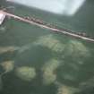
Aerial view of enclosure cropmark, Monboddo, north of Laurencekirk, Aberdeenshire, looking SW. |
7/1982 |
Item Level |
|
 |
On-line Digital Images |
SC 1970304 |
Papers of James Sloan Bone, landscape historian, Inverness, Highland, Scotland |
Aerial view of ring ditch cropmark, north of Monboddo, near Laurencekirk, Aberdeenshire, looking NE. |
1984 |
Item Level |
|
 |
On-line Digital Images |
SC 2411912 |
Records of the Ordnance Survey, Southampton, Hampshire, England |
Monboddo House, NO77NW 43, Ordnance Survey index card, Recto |
1958 |
Item Level |
|


