 |
On-line Digital Images |
DP 114073 |
RCAHMS Aerial Photography Digital |
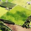
Oblique aerial view of the cropmarks of the palisaded enclosure with the House of Kinnaber and policies adjacent, taken from the W. |
24/6/2011 |
Item Level |
|
 |
On-line Digital Images |
DP 114075 |
RCAHMS Aerial Photography Digital |
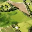
Oblique aerial view of the cropmarks of the palisaded enclosure with the House of Kinnaber and policies adjacent, taken from the NE. |
24/6/2011 |
Item Level |
|
 |
On-line Digital Images |
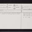
SC 2411709 |
Records of the Ordnance Survey, Southampton, Hampshire, England |
Fisherhills, NO76SW 8, Ordnance Survey index card, page number 1, Recto |
c. 1958 |
Item Level |
|
 |
On-line Digital Images |
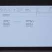
SC 2411710 |
Records of the Ordnance Survey, Southampton, Hampshire, England |
Fisherhills, NO76SW 8, Ordnance Survey index card, Recto |
c. 1958 |
Item Level |
|


