 |
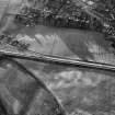
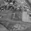
On-line Digital Images |
SC 1005320 |
Records of Aberdeen Aerial Surveys, Aberdeen, Scotland |
Oblique aerial view centred on the cropmarks of the unenclosed settlement, ring ditches, pits, possible souterrain and rig at Dryleys and Dubton, looking to the NNE. |
29/7/1983 |
Item Level |
|
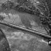 |
On-line Digital Images |
SC 1005321 |
Records of Aberdeen Aerial Surveys, Aberdeen, Scotland |
Oblique aerial view centred on the cropmarks of the unenclosed settlement, ring ditches, pits, possible souterrain and rig at Dryleys and Dubton, looking to the NNW. |
29/7/1983 |
Item Level |
|
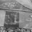 |
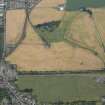
On-line Digital Images |
SC 1013260 |
Records of Aberdeen Aerial Surveys, Aberdeen, Scotland |
Oblique aerial view centred on the cropmarks of the unenclosed settlement, ring ditches, souterrain, pits and rig at Dryleys and Dubton, looking to the SSE. |
29/6/1982 |
Item Level |
|
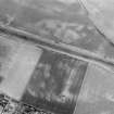 |
On-line Digital Images |
SC 1013262 |
Records of Aberdeen Aerial Surveys, Aberdeen, Scotland |
Oblique aerial view centred on the cropmarks of the unenclosed settlement, ring ditches, souterrain, pits and rig at Dryleys and Dubton, looking to the SE. |
29/6/1982 |
Item Level |
|
 |
On-line Digital Images |
SC 1013263 |
Records of Aberdeen Aerial Surveys, Aberdeen, Scotland |
Oblique aerial view centred on the cropmarks of the unenclosed settlement, ring ditches, souterrain, pits and rig at Dryleys and Dubton with Hillside adjacent, looking to the NNW. |
29/6/1982 |
Item Level |
|
 |
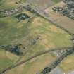
On-line Digital Images |
DP 163313 |
RCAHMS Aerial Photography Digital |
Oblique aerial view of the cropmarks of the unenclosed settlement, buildings, and rig, looking SSE. |
31/7/2013 |
Item Level |
|
 |
On-line Digital Images |
DP 166956 |
RCAHMS Aerial Photography Digital |
Oblique aerial view centred on the cropmarks at Dryleys, looking WNW. |
18/7/2013 |
Item Level |
|
 |
On-line Digital Images |
SC 2411744 |
Records of the Ordnance Survey, Southampton, Hampshire, England |
Dryleys, NO76SW 34, Ordnance Survey index card, Recto |
c. 1958 |
Item Level |
|
 |
On-line Digital Images |
SC 2411745 |
Records of the Ordnance Survey, Southampton, Hampshire, England |
Dryleys, NO76SW 34, Ordnance Survey index card, Recto |
c. 1958 |
Item Level |
|


