 |
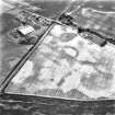
On-line Digital Images |
SC 1721819 |
RCAHMS Aerial Photography |
Oblique aerial view. |
1982 |
Item Level |
|
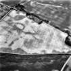 |
On-line Digital Images |
SC 1721820 |
RCAHMS Aerial Photography |
Oblique aerial view. |
1982 |
Item Level |
|
 |
On-line Digital Images |
SC 1721821 |
RCAHMS Aerial Photography |
Oblique aerial view. |
1982 |
Item Level |
|
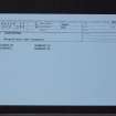 |
On-line Digital Images |
SC 2410557 |
Records of the Ordnance Survey, Southampton, Hampshire, England |
Langleypark, NO65NE 54, Ordnance Survey index card, Recto |
c. 1958 |
Item Level |
|
|
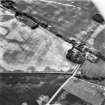
Photographs and Off-line Digital Images |
SC 2758773 |
RCAHMS Aerial Photography |
Oblique aerial view centred on the cropmarks of the ring-ditches, rig, pits, taken from the NW. |
3/8/2001 |
Item Level |
|


